


|
||

|

|
|

|
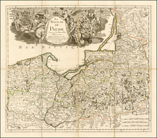
A rare and fascinating map of Central Europe published during the height of the Thirty Years' War.
This fine map grants a detailed overview of the heart of Europe during the Thirty Years' War (1618-1648). The map extends from Paris and London in the west to Lithuania and Serbia in the east, while it reaches from Italy's Po Valley in the south up to Copenhagen in the north. The map delineates all major rivers and waterways and labels innumerable towns. The key on the far lower left, 'Notes pour l'intelligence de ceste carte', explains the symbols used on the map to describe various different types of political jurisdictions and the seats of various noble houses and ecclesiastical domains (at the time, the Holy Roman Empire alone contained 212 separate autonomous political entities!). The map also employs the established symbol of 'crossed swords' to locate key battle sites in the ongoing war.
Devised in the 1630s, Tavernier intended for the map to provide a complete overview of the Thirty Years' War (1618-1648), a conflict that was then at its height. Previously, from the Peace of Augsburg (1555) to 1618, Central Europe was gripped by a 'cold war'. The Protestant and Roman Catholic rulers had uneasily avoided open conflict (although several wars raged along its periphery, most notably the Dutch War of Independence from Spain, also called the Eighty Years War, 1568-1648).
However, in 1618, the Protestant nobility of Bohemia rebelled against the increasingly conservative rule of their Habsburg Roman Catholic rulers. In an especially memorable incident, the council of nobles threw a party of imperial emissaries out of a third-story window, an incident known as the 'Defenestration of Prague'. In 1620, the Habsurgs brutally crushed the rebellion but this sparked a Europe-side war, that completely overcame Central Europe.
The war involved Austria, Bavaria, Spain and Poland-Lithuania (on the 'Roman Catholic' side) versus Sweden, Saxony, Prussia, Brunswick, England and France (on the 'Protestant' side, although curiously France was controlled by Cardinal Richelieu, a Prince of the Roman Catholic Church). The war raged for three decades and killed over 8 million people (such that it was proportionately more destructive than World War 2!).
The Peace of Westphalia (1648), which concluded the war did not yield a decisive victory for either side, however, both sides achieved some of their goals. The Catholic side saw that Austria, Bohemia, Bavaria and Cologne were purged of Protestant factions once and for all. France also dealt a deathblow to Huguenot rebels (although ironically France had fought on the Protestant side). On the other side, the Protestant Netherlands gained its independence from Spain and most of the Protestant German states were able to retain their religious affiliation, without further Vatican interference. The Westphalia Treaty is also seen as a major landmark in political and diplomatic history, as it saw the supremacy of the coherent nation state (ex. Spain, Netherlands, France, Sweden, etc.), as opposed to the continued precedence of multi-national dynastic empires.
Melchior Tavernier (1594-1665) was a Parisian map maker and engraver and the son of the print and bookseller Gabriel Tavernier. Melchior apprenticed under the master engraver Abraham Bosse, before establishing his own print shop with his brother Gabriel. In 1618, at only the age of 24, he was named to the prestigious position of official engraver to King Louis XIII and over the coming years moved to progressively larger premises. Cardinal Richelieu granted him a major commission of prints to celebrate the French government's defeat of the Huguenot rebels at La Rochelle, Éloges et discours sur la triomphante Reception du Roy en sa ville de Paris, après la réduction de La Rochelle (1629). Tavernier made many fine maps and often worked closely with the eminent cartographers Jean Boisseau and Pierre Mariette. His nephew was the famous adventurer and writer, Jean-Baptiste Tavernier (1605-1689).
The present map appeared as map #9, in volume 2 of Jean Boisseau's rare atlas,
Theatre des Gaules ou Descriptions Generales et Particulieres de toutes les Provinces du Royaume de France, avec les Provinces & Estats circonuoisins (Paris, 1637). The map is very rare on the market. We note no reported examples for the map selling seprately at auction or in dealers' records going back more than 30 years.
Melchior Tavernier was a member of a large family involved in the publishing trade in Paris in the early years of the seventeenth century. Early in his career, he apparently collaborated with Henricus Hondius, as at least one of his early maps references Tavernier as the seller of a map engraved in Amsterdam, by Hondius. He is probably best known for his publication of a map of the Post Roads of France, which was copied many times until the end of the century. He also issued an atlas under the same title as J. le Clerc's Theatre Geographique, using many of Le Clerc's maps, but incorporating others from different sources. He published composite atlases and also published works for other cartographers, including N. Sanson, N. Tassin, and P. Bertius. He is not to be confused with his nephew of the same name (1594-1665), who also engraved maps for Nicolas Sanson.
![[ Battle of Prague ] Schlacht bey Praag, in Böhmen, welche den 6. May 1757. von dem Koenig von Preussen, wieder der Kayserlichen Armee, unter Anführung des Prinzen Carls von Lothringen, gewonnen worden.](https://storage.googleapis.com/raremaps/img/small/95536.jpg)
![Constantinoplen en Egypten door Nicolaus Schmidt in enn zes Jarige Reystogt uyt Duytsland [shows Cyprus]](https://storage.googleapis.com/raremaps/img/small/57615.jpg)
![[ Vienna ] Viennense Territorium ob res Bellicas Inter Christianos et Turcas Nuperrime Editum](https://storage.googleapis.com/raremaps/img/small/80253.jpg)