|
||

|

|
|

|
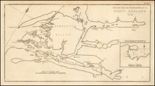
Finely detailed map of the central part of the North Island of New Zealand, centered on Lake Taupo, showing the region explored by J.H. Kerry-Nichols in 1883.
The map includes the names of newly discovered rivers, plains and lakes that were not previously shown on the maps, as well as the author's route and a data table of altitudes, camping places and principal stations of observations along the route traversed.
Kerry-Nichols provides an account of his explorations in the part of the North Island known as the King Country and Lake Country, traversing 600 miles through Maoriland and six hundred miles around King County just after the area was opened for railway survey and construction.
Kerry-Nichols's explorations resulted in the discovery of twenty-five rivers not previously shown on the maps and two small lakes; he examined the hydrography of lake Taupo, traced the sources of four of the principal rivers of the colony - the Whanganui, Waikato, Whangaehu, and Manganui-a-te-Ao - ascended Tongariro (7300 feet) and examined its active crater, ascended Mount Ruapehu (9000 feet), the highest peak of the North Island; ascended the Kaimanawa Mountains to an altitude of 4000 feet, examined the flora and collected some specimens of Alpine plants.
Kerry-Nichols provides a valuable description of the region of Lake Taupo, the Rangipo tableland, the Kaimanawa mountains, ascent of Tongariro and Ruaoehu, the Manganui a-te-Ao, hot springs of Tongariro, source of the Whanganui, and valley of the Waipa.
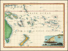
![Isles de Salomon [Early depiction of New Zealand!]](https://storage.googleapis.com/raremaps/img/small/101683.jpg)
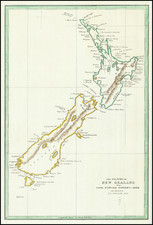
![Neu-Seeland [with] West Australien [with] Tasmania](https://storage.googleapis.com/raremaps/img/small/98073.jpg)