


|
||

|

|
|

|
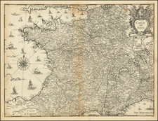
Scarce coastal map of the South of France, showing the area which includes Canes, Ile Sainte-Marguerite, and Ile Saint-Honarat.
Includes a number of sailing ships and sea monsters.
Tassin's atlas is the first set of charts to focus exclusively on the coast of France, and the earliest sea atlas published in France. Tassin's work enjoyed a long run of importance. Originally published by order of Cardinal Richelieu in 1634, Tassin would later sell the plates for his atlas to Antoine de Fer, who re-issued the atlas with some modifications. Antoine's son Nicolas De Fer would later re-issue with an addtional 10 plates and modification of the plates, in 1676, adding titles to the charts and adding a collection of fortifications. The charts were again re-issued by Pieter Mortier in 1695 and 1702.
The atlas is very rare on the market, with only a single example appearing in AMPR. For an illustration of the complete set of maps, please visit the website of the BNF: gallica.bnf.fr/ark:/12148/btv1b77100033
Nicolas Tassin (fl. 1633-55) was appointed 'royal cartographer' at Dijon before setting up as an engraver in Paris where he issued various collections of small maps and plans of France, Switzerland, Germany and Spain. Tassin first published his maps in his own atlas Cartes Generale de Toutes Les Provinces de France in 1634, with an enlarged second edition in 1637 (France, royaumes et provinces d'Europe).
![Generale Caert van Vranckryck [General Map of France]](https://storage.googleapis.com/raremaps/img/small/93273.jpg)
![Gallia Narbonens [on sheet with] Savaudiae Ducat. [on sheet with] Venuxini Comitatus Descr.](https://storage.googleapis.com/raremaps/img/small/61471.jpg)