|
||

|

|
|

|
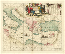
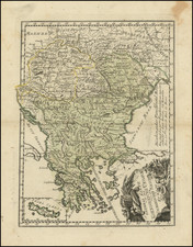
A very rare 'Lafreri School' map of the Peloponnese, printed by Claudio Duchetti in Rome in 1570.
The important and finely engraved map of the Peloponnese (sometimes called Morea) captures the historical heart of the Hellenic Civilization. It labels all of the traditional regions of the peninsula: Achaia, Messenia, Elis, Arcadia, Argolis and Laconia. It also features many locations that are famed in Classical history and in Homer's epics, the Iliad and the Odyssey. These include 'Coryntus' (Corinth, which guards the isthmus separating the Peloponnese from mainland Greece), 'Mycene' (Mycenae, the great archaeological site, the largest city in 2nd Millennium B.C. Greece), Argos, 'Nauplia' (Nafplio, a key port called Napoli by the Venetians), 'Patre' (Patras, today the largest city in the Peloponnese), Sparta (once controlled by famously stoic warriors), 'Phylus Nestorea' (Pylos, home of King Nestor of Homeric fame), and the fabled islands of 'Zacinthus' (Zakynthos, called Zante by the Venetians) and 'Cythere' (Cythera, called Zerigo by the Venetians).
To the northeast of the peninsula, in Attica, is 'Athene' (Athens) and its great port, 'Pirens' (Piraeus), while the nearby island of Salamis lies near the location of a legendary naval battle, fought in 450 B.C., during which the Greeks, under the Athenian general Themistocles, decisively defeated a much larger Persian fleet.
Duchetti's map is only the second printed map of the Peloponnese, preceded only by Francesco Camocio's Morea Peninsula, et prouincia principale della Grecls antiquamente nominara Lacedemonia (Venice, 1569).
Not long after this map was issued, the Peloponnese was at the top of the news throughout Europe. Just to the west of 'Naupactus', located on the map (on the north shore of the Gulf of Corinth), on October 7, 1571, the Allied Christian fleet under Don Juan of Austria (with ships from Venice, various other Italian states, Spain and Malta) crushingly defeated the Ottoman Empire's main fleet. The Battle of Lepanto was the largest naval battle ever fought to date, involving 462 ships and almost 150,000 sailors and soldiers. The result of the battle devastated Ottoman naval capability for decades, and ensured that the Turkish empire developed as more of a land power than a maritime threat. In spite of the battle, however, the Peloponnese (which had earlier been dominated by Venice) would remain in Ottoman hands until the Greek War of Independence (1821-32).
Claudio Duchetti (born in France as Claude Duchet, d. 1585) was an important 'Lafreri School' cartographer. He was the nephew of Antonio Lafreri (1512-77, born Antoine du Pérac Lefréry in Besançon, Burgundy). Lafreri settled in Rome in 1540, and by 1544 had opened his own engraving and print selling business on the Via del Perione. From 1553 to 1562, he formed a commercial alliance with the veteran dealer Antonio Salamanca. Following that time, he published on his own account. Importantly, Lafreri was primarily a dealer and publisher, rather than an artisan in his own right. He carried a vast stock of maps and prints made by other printers from both Rome and Venice. He became known for producing IATO (Italian-Assembled-To-Order) atlases, each unique composite atlases featuring a selection of fine Italian maps, made to the tastes of individual clients. Owing to the popular acclaim of these atlases, while the term was never used during this period, the Italian maps from this era are today often said to be of the "Lafreri School."
Claudio Duchetti worked closely with his uncle, but also published many maps, including the present map of the Peloponnese, under his own name. When Lafreri died, Duchetti inherited many of his plates and published new editions of Lafreri maps. When Duchetti passed, his main heir, Giovanni Orlandi, inherited his plates and continued publishing 'Lafreri School' maps until the early years of the 17th Century.
Duchetti's map of the Peloponnese is one if the truly great early printed maps of Greece. It is also very rare. We are aware of only a single other example appearing on the market during the last 25 years.