


|
||

|

|
|

|
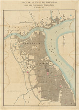
A highly attractive Art Deco style tourism map of the environs of Beijing, printed in China during the 1930s.
This fine pictorial map was issued in the 1930s, when Western travel to China was all the rage, as it is now, once again. Wealthy Americans and Europeans were lured by the grand and exotic historical sights, fine hotels and swinging night clubs in the heady days immediately before World War II and the rise of Communism. Of the major Chinese destinations, Beijing, with its sophisticated culture and finely preserved imperial treasures was considered to be the most refined destination. Adding to the scene, Beijing was also a center of diplomatic intrigue and espionage as the city hosted the embassies of competing world powers.
The map embraces the Greater Beijing area, then called by Westerners "Peking" or "Peiping". The discrepency is based on the fact that Europeans tended to use Cantonese pronunciation to transliterate Manadarin Chinese names (for years almost all of Western contact with China occurred in Cantonese-speaking areas). The old walled city occupies the center of the map, divided into the "Chinese City", the "Legation Quarter" (home to foreign embassies), the "Tatar Quarter" (the 'Manchurian District') and the Fobidden City, the traditional sacred home of the Emperor (although China had been a republic since 1911).
From Beijing radiates a series of transportation networks, all expressed though Art Deco symbols, including major roads, railways and the two airports which serviced the city. These routes link up to major attractions in the country outside of the city, also identified with their custom pictographs, including the Great Wall, the Ming Tombs, the Summer Palace, the Miao Fang Shan Waterfall, the Jade Fountain and Pagoda. Many of these sites are located at the 'Western Hills' to the west and northwest of Beijing, which are expressed by a bold area of green printing. Notes in the upper right refer to 2 sites located off of the map, "Hsi Ling", or the Western Tombs, located 100 miles southwest of Beijing; and "Tun Ling", the Eastern Tombs, located 70 miles east of the city. Various local modes of transport are pictorially represented, such as horseback riding and being carried in a palanquin by guides. Key recreational sites such as golf courses are noted, as well as tips for accomodation, such as "Nankow (good foreign hotel here)".
The map was designed by John Kirk Sewall, an American illustrator, who created another map detailing the city of Peking proper (1930s) as well as illustrating the popular cookbook, Corinne Lamb's The Chinese Festive Board (1935).
The publisher, the Peiyang Press, was one of the leading printer's maps, books and views geared to a Western audience in China during the Republican period. The company was founded in 1924, with offices in Tianjin and Beijing, and operated until the Communist Revolution in 1949. Notable publications included Alice Leighton Cleather and Basil Crump's Buddhism: The Science of Life (1928), Robert M. Duncan's Peiping Municipality and the Diplomatic Quarter (1933), a Chinese-Dutch dictionary (1935) and a 1937 album of black and white photographs of British military exercises in China celebrating the coronation of George VI. They also published a Map of Tientsin (1941), Frank Dorn's pictorial A Map and History of Peiping and both of John Kirk Sewall's maps of Beijing and environs.
The present map is one of the finest pictorial maps of a Chinese region made during the great Art Deco period.
![[ Hong Kong, Canton & Environs ] Carte des Isles qui sont a L'Entree de la Riviere De Canton](https://storage.googleapis.com/raremaps/img/small/74493.jpg)
![Parte Occidentale della China . . . [with] Parte Orientale della China . . .](https://storage.googleapis.com/raremaps/img/small/75144.jpg)