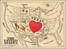
|
||

|

|
|

|
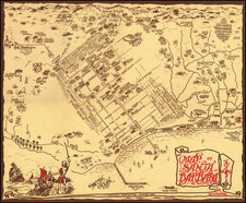
An attractive and engaging 1950s pictographic map of Moscow, showing the Soviet capital's main sites during the height of the Cold War.
This interesting map provides a rare Western-language pictographic map of Moscow, then the capital of the Soviet Union, and one of the intriguing enigmas to Westerners. The map features the center of the city, with the Kremlin the middle. Curiously, while the walls of the Kremlin are outlined, no details with respect to the buildings inside are included. As the Kremlin was the epicenter of the Soviet government, no foreigners were allowed to visit the complex, and so details were removed so as not to encourage any 'undue curiosity'. Key illustrated sites include Red Square, Lenin's Mausoleum, the Hotel Metropole, the Bolshoi Theatre, St. Basil's Cathedral, amongst many others. A key in the lower right identifies 19 general sites, 38 theaters, 18 museums, 11 monuments, 8 train stations, 4 hotels, and the "Intotourist" travel center.
The map is undated, but based on style and political reasons, was printed in the mid to late 1950s. It was issued by Editions Vnechtorgisdat, a Soviet government-run printing office, which specialized in issuing maps and guides to foreigners, and was designed by Mikhail Getmanski. The present piece is one of at least two known editions of the map. It was printed in French, as while English was favored by North Americans and Britons, many Continental Europeans (especially diplomats) were during this time more comfortable with the French language.
Following the death of Soviet dictator Joseph Stalin in 1953, the political climate within the Soviet Union was eased somewhat under the new leader, Nikita Krushchev. While tensions between the West and the USSR remained high (almost coming to war during the Cuban Missile Crisis in 1962), it was now possible for Westerners to visit Moscow as tourists, although their movements were to be carefully guided and supervised by Soviet agents. This map was printed for the small number of truly curious Westerners who ventured to Moscow, as well as members of the sizeable foreign diplomatic corps in the city.
The map is a highly detailed and attractive overview of Moscow in the 1950s, a city seldom visited or understood by Westerners, although it occupied the top of the news throughout the Cold War.