|
||

|

|
|

|
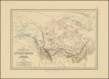
A fascinating contemporary ephemeral map of the theatre of the Lower Canada Rebellion of 1837, a seminal event in the history of Quebec.
The map focuses on the heavily populated Montreal-Quebec City corridor of the Province of Lower Canada (modern Day Quebec). It shows all major towns and transport corridors including rivers and roads, as well as adjacent United States territory.
The map shows the theater of the Lower Canada Rebellion of November-December 1837. During this brief uprising, French Canadian Patriotes led by Louis-Joseph Papineau and a small number of American sympathisers took up arms against the British colonial regime. They were motivated by discontent with the "Château Clique", the province's ruling oligarchy of British merchants and pro-British French Canadians.
The rebellion was dealt a severe blow when government forces defeated the Patriotes at St. Eustache, on November 25, 1837 (shown on the map north of Montreal) and was finished off by another government victory at St. Charles (near Quebec City), on December 14, 1837, although news of this would not have been taken into account on the map (published only 2 days later). While the rebellion was unsuccessful, it led to gradual democratic reforms and the eventual Confederation of Canada.
The map was published in a newspaper, likely in London, on December 16, 1837.
![[Unique Extra-Illustrated Example!] Carte Nouvelle Contenant La Partie d'Amerique La Plus Septentrionale, . . . Le Canada ou Nouvelle France, La Nouvelle Ecosse, La Nouvelle Angleterre, Les Nouveau Pais Bas, La Pensylvanie . . . Et Jle. de Terre Neuve . . .](https://storage.googleapis.com/raremaps/img/small/47720.jpg)