


|
||

|

|
|

|
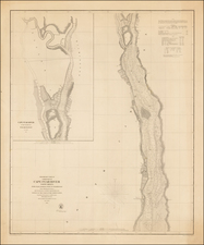
Joseph Smith Speer's rare chart of Cape Fear, North Carolina, from his West India Pilot, and exceptional example with original wash color.
This rare and important chart focuses on the Cape Fear area, then the principal maritime gateway to North Carolina, leading to the key port of Wilmington. Shown here is the famous Cape itself, along with the mouth of the Cape Fear River. Carefully outlined are the treacherous shoals which gave the cape its name, including the offshore Frying Pan Shoal and the Middle Ground, which guarded the mouth of the river. Shown in the far upper center of the chart, along the bank of the river is Fort Johnston, built in 1749, it was notably the only military base in coastal North Carolina, and would later be the scene of much drama during the opening days of the American Revolution, in 1775. Adjacent to the fort are the "Pilots Houses", indicating that, even with this chart, it was well advised to have the aide of local guides to avoid the shoals.
Speer's chart represents only the second printed map to focus on the Cape Fear area, the first being Thomas Jefferys's exceedingly rare A New and Exact Plan of Cape Fear River from the Bar to Brunswick (London, 1753), which is itself based on Edward Hyrne's 1749 manuscript.
The present chart is an original production, perhaps based on the surveys of Captain Speer himself. The chart was first issued in Speer's The West India Pilot (London, 1766), an atlas of harbors, which focused on the West Indies, but included the Cape Fear map as one of its 13 charts. An expanded second edition of the atlas was issued in 1771, with 26 charts, including two of American waters (Cape Fear and Jekyll Sound, Georgia). The present example of the Cape Fear chart can be identified as the second state of 1771, as it incudes the publisher's note "to face page 53" in the upper right corner, while the 1766 state features a small "13" just outside of the neatline in the upper right corner.
The West India Pilot was highly consequential in that it influenced a number of important subsequent publications. Several of Speer's charts were also copied by the London publishers of Robert Sayer & John Bennett from 1776 onwards as well as by France's Dépôt de la Marine from 1778 onwards. Most interestingly, the Spanish Dirección de Hidrografía's Portulano De La America Septentrional (Madrid, 1809), an atlas of harbor charts of the West Indies, maintained a similar format and size and copied several of Speer's charts.
Speer subsequently issued A General Chart of the West Indies (1774), a fine large-scale chart of the region, which featured an engraved endorsement by John Pownall, Secretary to the Plantation Office, certifying that the chart incorporates the "latest and most accurate surveys." In 1773, he published a series of charts relating to ports in Portugal and Spain.
In spite of his publications, little research has been conducted into Captain Joseph Smith Speer, a Royal Navy officer, who had long service in the West Indies. The papers of Lord Darmouth, the British colonial minister, include a letter from Speer to Dartmouth, dated November 5, 1765, with author relating that "On his arrival [in London from the West Indies], he met with his creditors who immediately put him in [debtor's] prison". Speer attributed his financial misfortune to the large amounts of his own money he was "obliged to spend" in "doing the duty he was ordered" towards fighting the Spaniards. He furthermore noted that he had served in the Royal Navy in West Indies and "Musketoe Shore" (Nicaragua) for 21 years without interruption. He petitioned Dartmouth to help him gain "relief and promotion" from the King. It is not known if Dartmouth intervened on his behalf, but it was clear that Speer was soon released from custody. The publication of the West India Pilot and his large chart of the West Indies were likely, in good part, motivated by an attempt to recover his finances. Speer died in Cadiz in 1781, while in Spanish custody, his regiment having been captured the year before during hostilites related to the American Revolution.
The present example of Speer's Cape Fear chart is exceptionally fine, as it includes original blue wash color in the seas, an embellishment rarely seen on surviving examples of charts from the West India Pilot. Both the chart and the atlas in which it appears are very rare. Only a few examples of either edition of the complete West India Pilot have appeared in the market in the last 25 years, and the separate appearance of the individual charts is unusual. This is the first example of the Cape Fear chart, being offered individually, that we have ever seen.
Cape Fear', no.5 (online).


![[ Extensively Annotated By An Early Owner ] Georgia from the latest Authorities](https://storage.googleapis.com/raremaps/img/small/100877.jpg)
![[ Carolinas & Georgia ] Carte De La Caroline Et Georgie . . .](https://storage.googleapis.com/raremaps/img/small/99744.jpg)