|
||

|

|
|

|
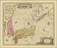
Fine example of this rare and highly important map of Japan, by German physician and traveler Philipp Franz von Siebold.
This highly significant map is the first truly modern map of Japan printed in the Western world, based upon information obtained by Siebold during his travels in Japan, primarily the groudbreaking surveys made by the Japanese cartographer Ino Tadataka. It represents a radical improvment over all previous maps of Japan, and was by far the most accurate impression of the islands available during the opening of Japan to Westerners, following the visit of American Commodore Matthew C. Parry in 1854.
The main map embraces most of Honshu and all of Shikoku and Kyushu. Hokkaido, referred to as "Jezo", is essentially absent, for it had not yet been properly mapped. Insets include the northern tip of Honshu (in the upper left) and a detailed sea chart of the Harbor of Nagasaki (in the lower right), which was the only port in Japan then open to western commerce. Overall, the geography is shockingly modern and accurate, especially in comparison to earlier maps of the islands. Due to the Japanese Shogunate's longtime restrictions on foreign visitation to the country, Japan was one of the last heavily populated regions of East Asia to be comprehensively mapped by westerners. Siebold's work thus represents a major milestone, as postions were clearly regulated by astronomical observations, placing the map within its correct geodetic framework. Great care is taken to label the locations of mountains, roads, prefectural boundaries, and towns. Siebold, who was a keen ethnographer, even provides a table translating Japanese geographical terms into German (along the right side of the map).
One interesting feature of the map is the inclusion of the island of "Argonaut", a mis-identification of the Korean island of Ulleungdo, originally made by the captain of the HMS Argonaut in 1789. British Captain James Colnett mismapped Ulleungdo at the coordinates 37º 32' N and 129º 50' E, resulting in the island of "Argonaut" showing up on many western maps to the northwest of Ulleungdo, which at the time was referred to on western maps as Dagelet Island. Siebold names the island "Takeshima," which was the Japanese name for Ulleungdo, and the real Ulleungdo as "Matsushima," which was the Japanese name for Liancourt Rocks.
Dr. Siebold's inclusion of the island was of significant consequence as his map was deemed authoritative by many. Of note, in 1876, a Japanese businessman Mutoh Heigaku, petitioned the Japanese government to develop Matsushima, which he believed to be Japanese territory.
Phillip Franz von Siebold & the Mapping of Japan
Phillip Franz von Siebold (1796-1866) was a German physician, who joined the service of the Dutch East India Company (the VOC). In 1822-23, he travelled to Batavia (modern Jakarta), the capital of the Dutch East Indies. Residing in Japan from 1823, he quickly made contact with the country's leading scholars, as well as many senior political officials, and steadily acquired an unprecedented collection of botanical and ethnographic specimens. Sielbold's intense intellectual curiosity also led him to search for the most advanced cartography of East Asia.
The present is from Siebold's epic study of Japan and Korea, Nippon. Archiv zur Beschreibung von Japan und dessen Neben- und Schutzländern: jezo mit den südlichen Kurilen, Krafto, Koorai und den Liukiu-Inseln (7 volumes, printed in Leiden, Netherlands, 1832-1852). Highly detailed and profusely illustrated, it was by far the finest and most important European study of the history, ethnography, geography and flora and fauna of Japan and Korea published to date. More than any other work, it showcased Japan and Korea to western intelligentsia, on the eve of the wholesale opening of these countries to European trade and exchange.
Sielbold's intense intellectual curiosity led him to search for the most advanced cartography of Japan and Korea. While on a visit to Edo (modern Tokyo) in 1826, he befriended Takahashi Kageyasu, the Japanese court astronomer, who provided him with a series of sophisticated maps, many of which were by the late Ino Tadataka (1745-1818). Tadataka famously conducted the first modern mapping of Japan, as well as compiling maps of Korea from the latest sources.
Curiously, it was Siebold's interest in cartography that led to the so-called "Siebold Incident", which resulted in his expulsion from Japan. While the Japanese authorities seemed tolerant, if not a little bemused, by Siebold's endeavors to collect natural specimens, this indulgence had its limitations. In 1829, when officials accidentally discovered Siebold's map collection, they were aghast that a foreigner possessed sources that contained such accurate and detailed geographical intelligence and military information. Accusing him of being a Russian spy, they placed him under house arrest, before expelling him from the country. Surprisingly, the Japanese authorities did not confiscate all of Siebold's maps, allowing him to take them back to Europe.
Upon Siebold's return to Europe in 1830, he settled in the Dutch university town of Leiden. He soon opened a magnificent museum for his specimen collection, and set to work on his monumental publication of Nippon, a project that would last 20 years. During this period he carefully prepared finished manuscript maps, in preparation for them to be lithographed.
We locate no examples of this map on the market for more than 30 years. One of the most historically important maps of Japan, it is also one of the most difficult to obtain.
![[Japan] Carte Des Decouvertes au Nord du Japon Faites en 1643 par les Vaisseaux Hollandais le Kastrkum et le Breskens, Comprenant la Terre de Jeso, I'Ile des Etats et la Terre de Compagnie, dont partie a ete reconnue en 1787 . . .](https://storage.googleapis.com/raremaps/img/small/49803.jpg)
![Yeddo [Tokyo]](https://storage.googleapis.com/raremaps/img/small/90217.jpg)