This item has been sold, but you can enter your email address to be notified if another example becomes available.


|
||

|

|
|

|
Stock# 37636
Description
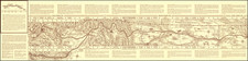
Fine map depicting details within the Wind River Reservation in Wyoming.
The map shows early settlements, forts, rivers, mountains and township surveys.
The Wind River Indian Reservation was established for the Eastern Shoshone Indians in 1868. Camp Auger, a military post with troops, was established at the present site of Lander on June 28, 1869. In 1870 the name was changed to Camp Brown and in 1871 the post was moved to the current site of Fort Washakie. The nickname was changed to honor the Shoshone Chief Washakie in 1878 and continued to serve as a military post until its abandonment in 1909.
![(Humboldt Atlas and Text) Geographique et Physique du Royaume de Nouvelle-Espagne [with quarto text:] Essai Politique de la Royaume de la Nouvelle-Espagne](https://storage.googleapis.com/raremaps/img/small/99796.jpg)