|
||

|

|
|

|
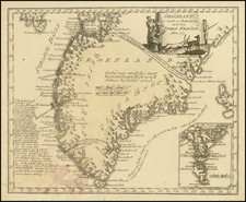
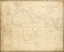
A Rare Henri de Leth map of the Southern Hemisphere, with an additional text panel pasted to the right side of the map, made especially to commemorate Bouvet's 1738-9 voyage.
This second state of De Leth's fascinating map captures the entire Southern Hemisphere from a polar projection. This rare variant example includes an additional text panel describing Bouvet's voyage, pasted to the right side of the map. The cartography features many of the contemporary myths and anomallies associated with the Antipodes. The map featues excellent projections of Australia and New Zealand, along with a number of early routes of exploration from the 16th, 17th and 18th Centuries, including Tasman, Halley, Damiper, Magellan, Le Maire, Mendana and others.
The second state of the map includes the following additions and changes:
- Bouvet route, and marginal map and information
- The "port", allegedly discovered by Sir Francis Drake, otherwise known as Drake's Island, in 1577, which lies to the southwest of Cape Horn
- The discoveries of Captain Davis and Captain Sharp to the west of the Straits of Magellan
- The annotations regarding Amerigo Vespucci's voyage to the Southern Hemisphere
- Different text in the lower corners and far fewer place names along the Chilean coast of South America
- Notes the islands discovered by Roggeveen in 1722
- More detail in New Zealand
Some of the more notable features are Edmund Halley's sighting of Antarctic ice; Bouvet's large Cap de la Circoncision; Carpentaria attached to New Guinea; Tasman's route, along with a depiction of Tasmania as per Tasman, distinctly separate from Australia.
Emphasized on the map (heightened in orange) is the route of the 1738-9 voyage of Jean-Baptiste Charles Bouvet de Lozier (1705-86), commanding the ships Aigle and Marie, undertaken at the behest of the French East India Company. Bouvet's mandate was to find the apocryphal great southern continent. The text mentions Bouvet's discovery of icebergs between two and three hundred feet high and half a league to two or three leagues in circumference. On January 1, 1739, Bouvet encountered an icy promontory, which he named Cap de la Circoncision, at 54° South, below Africa, supposedly located next to one of the openings of his polar sea, where he had recorded his many great icebergs. An inset in the lower right of the map details this discovery.
Importantly, this was the first time land had been spotted beyond the 50th parallel South in the Eastern Atlantic. Bouvet, spotted Cap Circoncision, but severe fog and ice ensured that he was unable to explore the area further, and was thus he was unaware that the landmass was part of an island, and not a southern continent. Bouvet lost sight of the cape and was unable to relocate it in the days that followed. For many decades after this map was printed, it remained a mystery as to the true nature of this discovery. Bouvet's plotting of his course was innacurate, and in spite of several attempts, the cape was not encountered again until 1808, when it was proven to be an island. Named Bouvet Island, it is one of the World's most isolated points of land, very distant from both Africa and Antarctica, and is today administered by Norway.
The map is quite rare. We could not locate any examples at auction or in dealer catalogs in more than 30 years. We found only a single example illustrated on line with the extra text panel (National Library of Australia).