|
||

|

|
|

|
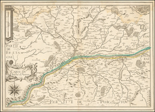
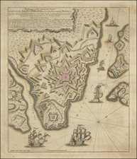
An attractive map of the Ile de Ré depicting its key role in the War of the Grand Alliance (1688-97).
Ile de Ré is an island in the Bay of Biscay, guarding the approaches to the important port of La Rochelle. The principal town of St. Martin was fortified by Sebastian de Vauban in 1681. The island managed to withstand an assault by a combined Anglo-Dutch fleet, in 1696, during the War of the Grand Alliance (1688-97), which pitted Louis XIV's France against a coalition of several major European powers.
The map is from De La Feuille's Atlas Portatif, ou le nouveau Theatre de la Guerre en Europe; Contenants les cartes geographiques, avec les plans des Villes & Forteresses les plus exposees aux revolutions presentes (Amsterdam, 1706), which contained many maps depicting key sites in the late war.
Today the Ile de Ré is one of France's most favored vacation spots, and the present map highlights its role in a key historical event.
![[ Holy Roman Empire, Poland, Baltic, etc. ] Germania VI Nova Tabula (First state!)](https://storage.googleapis.com/raremaps/img/small/94645.jpg)