


|
||

|

|
|

|
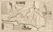
A fine mid-18th Century plan of Paris, with full wash color.
This attractive map features all of Paris as it appeared during the mid years of the rule of Louis XV (reigned 1715-1774), when Paris had a population of over 500,000. A long note at lower right explains that Paris is divided into three parts, namely the City, the Town and the University. A lettered key names and locates 23 important buildings, streets, churches, palaces, gardens, boatyards, orchards, and hotels. Key landmarks that still survive to this day, include the Louvre, the Tuilleries Palace, the Cathedral of Notre-Dame, and the Luxembourg Palace. The lines of the old medieval walls of Paris are still evident, although much of the wall had already been torn down. The infamous Bastille is located to the right of the map.
The map was made by Matthäus Seutter (1678-1757), one of the period's leading map makers, based in Augsburg.
Matthäus Seutter (1678-1757) was a prominent German mapmaker in the mid-eighteenth century. Initially apprenticed to a brewer, he trained as an engraver under Johann Baptist Homann in Nuremburg before setting up shop in his native Augsburg. In 1727 he was granted the title Imperial Geographer. His most famous work is Atlas Novus Sive Tabulae Geographicae, published in two volumes ca. 1730, although the majority of his maps are based on earlier work by other cartographers like the Homanns, Delisles, and de Fer.
Alternative spellings: Matthias Seutter, Mathaus Seutter, Matthaeus Seutter, Mattheus Seutter
![Regionis Biturigum Exactiss: Descriptio Per D. Ioannem Calamaeum [with] Limaniae Topographia Gabriele Symeoneo Auct.](https://storage.googleapis.com/raremaps/img/small/61579.jpg)
![[Battle of Moncontou] Victoria di chatolici contra Hugonoti](https://storage.googleapis.com/raremaps/img/small/75053.jpg)