|
||

|

|
|

|
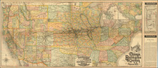
Rare separately issued map of the United States, published by Edward Stanford & Co. to meet demand in England for information concerning the War in America.
The map highlights the southern United States which had seceded from the Union and were then at war with the northern states, which are divided from the northern states by a red line.
Among the most notable features of the map are the unusual western territorial boundaries. Among the more interesting boundaries are:
- Nevada-Utah, still shown in its initial configuration, with the boundary 2 degrees west of its final position.
- New Mexico-Arizona Territorial Border, reflecting the so-called "Baylor Line," which demarcated the disputed confederate Arizona Territory, an area south of New Mexico, which divided New Mexico Territory at the 34th Parallel. While the US Federal Government created what Arizona Territory in what would become its modern configuration, the Confederates recognized an earlier version of Arizona Territory, which consisted of the southern part of New Mexico Territory.
- Extra piece of Utah extending above Colorado.
- Washington and Oregon extending to the Rocky Mountains, prior to the creation of Idaho
- Massive Nebraska Territory, pre-dating Montana, Wyoming and the modern configuration of the Dakotas, which then only extended to the Missouri River.
Of the group above, the story of Confederate Arizona Territory is the most interesting. As early as 1856, there were serious doubts about the governance of the remote parts of New Mexico Territory to the south and the west. The first proposal for splitting New Mexico Territory (at the 32nd Meridan), was adopted by the New Mexico Legislature in 1858.
In April 1860, impatient for Congress to act, a convention was called and 31 delegates met in Tucson. In July 1860, the convention drafted a constitution for a "Territory of Arizona" to be organized out of the New Mexico Territory south of the 34th Parallel. The convention elected Lewis Owings as the Territorial Governor, and elected a delegate to Congress. The proposal failed in Congress because of opposition from anti-slavery Congressmen. Many people in the area were pro-slavery, with business connections in southern states, and this new territory lay below the old Missouri Compromise line of demarcation between slave and free states. Thus anti-slavery Congressmen feared that the new territory might eventually become a slave state.
Sentiments in Arizona remained highly supportive of the territory. Arizonan's felt neglected by the United States government. There were too few troops to fight the Apaches who were terrorizing travelers, ranches and mining camps. The closing of the Butterfield Overland Mail stations which connected the Arizona frontier colonies to the east and California was also a major concern. In March 1861, the citizens of Mesilla called a secession convention to separate themselves from the United States and join the Confederacy. On March 16, a secession ordinance wash passed in Mesilla and a second ordinance was passed March 28, 1862 in Tucscon. The Confederacy would later admit Arizona Territory to the Confederacy in February 1862.
As the British were supporters of southern independence, the depiction of the Confederate Arizona Terrirtory was consistent with British foreign policy.
The government of Confederate Arizona Territory was very short-lived. Following the Confederate victory at the Battle of Mesilla, a government was formed, with Messilla as its capital. Confederate hold in the area was soon broken, however, after the Battle of Glorieta Pass. In July 1862, the government of the Confederate Territory of Arizona relocated to El Paso, Texas, where it remained for the duration of the war. The territory continued to be represented in the Confederate Congress and Confederate troops continued to fight under the Arizona banner until the war's end.
The map is of the utmost rarity. OCLC locates only a single example of the 1861 edition of this map, in the collection of David Rumsey. No examples of the 1863 edition are recorded.
Edward Stanford (1827-1904) was a prominent British mapmaker and publisher. A native of Holborn in the heart of London, Edward was apprenticed to a printer and stationer at the age of 14. After his first master died, he worked with several others, including Trelawny W. Saunders of Charing Cross. Saunders oversaw young Edward’s early career, ensuring that he became a Fellow of the Royal Geographical Society. Associations with the Society eventually brought Sanders much business and gave him a reputation as a publisher of explorers. As testament to this reputation, the Stanford Range in British Columbia was named for him by John Palliser.
Stanford briefly partnered with Saunders in 1852 before striking out on his own in 1853. He was an agent for the Ordnance Survey, the Admiralty, the Geological Survey, the Trigonometrical Survey of India, and the India Office. He also controlled the maps of the Society for the Diffusion of Useful Knowledge, another lucrative source of income. In 1857, Stanford founded his namesake Geographical Establishment, with Saunders and A. K. Johnston as engravers. Thereafter, Stanford was known for his “library maps”, particularly those of Africa and Asia.
Addresses and Years of Operation:
- 6 Charing Cross, London (1848): Edward Stanford's initial place of employment at Trelawney Saunders' shop.
- 7 and 8 Charing Cross, London (1853): Stanford expanded his shop to these addresses.
- 55 Charing Cross, London (1873): The shop moved to this larger location.
- 12-14 Long Acre, London (1873): Site of the new print works and current flagship store.
- 7 Mercer Walk, London (2019): Stanfords moved to this address, continuing its legacy.
Stanford's work with Chief Cartographer John Bolton, including the 1858 Library Map of Europe, positioned the company as a leader in quality cartography during a time of exploration and colonialism. Their 1862 Library Map of London earned acclaim from the Royal Geographical Society. With the business thriving, Stanford purchased Staunton & Son in 1877 and, upon retiring in 1885, handed over the reins to his son, Edward Stanford II.
As sole agents for Ordnance Survey Maps, the company's influence and reputation grew, culminating in the Stanford’s London Atlas Of Universal Geography, which was presented to Queen Victoria in 1887. The transition into the 20th century saw further integration of retail, print, and cartographic operations at Long Acre.
During World War I, Stanford's became an essential publisher for the War Office. Edward Fraser Stanford took over in 1917, steering the company through the interwar period and innovations, such as the world’s smallest maps in 1922 and the Daily Mail Motor Road Map in 1926.
Withstanding a bombing in WWII, the company continued under the stewardship of John Keith Stanford and was sold to George Philip & Son in 1947. As it adapted to the digital age, Stanfords received the Ordnance Survey Premier Partner status in 2007 and ventured into online mapping and data services.
Stanfords, now an icon for travellers and explorers, has maintained its cultural relevance and retail success well into the 21st century, underpinned by a legacy of entrepreneurial spirit and commitment to cartographic excellence.
![[ English Plantations in North America ] A New Map of the most Considerable Plantations of the English In America Dedicated to His Highness William Duke of Glocester.](https://storage.googleapis.com/raremaps/img/small/98233.jpg)