|
||

|

|
|

|
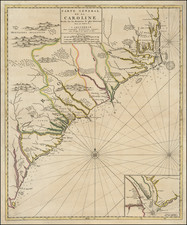
Detailed map of the Carolinas, Georgia and East Florida, extending from the Appalachians and eastern Tennessee and west Florida to Virginia and Cape Charles, from John Oldmixon's important book on the British colonies in America.
The map features the the Atlantic Seaboard from what is now southern Georgia all the way up to Cape Charles at the mouth of Chesapeake Bay. Charles Town (Charleston, South Carolina), founded in 1670, is depicted and plantations are noted by a symbol identified by a line under the title, "Note that ye plantations are marked thus".
The map is from volume 1 of John Oldmixon's The British Empire in America (London, 1708), one of the most important early treatises on Britain's colonies in America.
Herman Moll (c. 1654-1732) was one of the most important London mapmakers in the first half of the eighteenth century. Moll was probably born in Bremen, Germany, around 1654. He moved to London to escape the Scanian Wars. His earliest work was as an engraver for Moses Pitt on the production of the English Atlas, a failed work which landed Pitt in debtor's prison. Moll also engraved for Sir Jonas Moore, Grenville Collins, John Adair, and the Seller & Price firm. He published his first original maps in the early 1680s and had set up his own shop by the 1690s.
Moll's work quickly helped him become a member of a group which congregated at Jonathan's Coffee House at Number 20 Exchange Alley, Cornhill, where speculators met to trade stock. Moll's circle included the scientist Robert Hooke, the archaeologist William Stuckley, the authors Jonathan Swift and Daniel Defoe, and the intellectually-gifted pirates William Dampier, Woodes Rogers and William Hacke. From these contacts, Moll gained a great deal of privileged information that was included in his maps.
Over the course of his career, he published dozens of geographies, atlases, and histories, not to mention numerous sheet maps. His most famous works are Atlas Geographus, a monthly magazine that ran from 1708 to 1717, and The World Described (1715-54). He also frequently made maps for books, including those of Dampier’s publications and Swift’s Gulliver’s Travels. Moll died in 1732. It is likely that his plates passed to another contemporary, Thomas Bowles, after this death.

![[ Southern Railroads ] Railroad Map of the Southern States Shewing the Southern & Southwestern Railway Connections With Philadelphia. 1862 . . . Prepared by Thomas Kimber Jr., Chairman of the Committee on Inland Transportation of the Board of Trade of Philadelphia](https://storage.googleapis.com/raremaps/img/small/103211.jpg)