


|
||

|

|
|

|
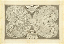
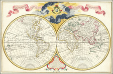
Fine example of the Antoni Lafreri edition of Antonio Salamanca's double cordiform map of the World, first published circa 1550 in Rome.
The first Lafreri state of Salamanca's map was issued in 1564 in Rome by Antonio Lafreri, Salamanca's former business partner. Larferi (born Antoine du Pérac Lafréry 1512-77) is best known for being the Roman map publisher for whom the 'Lafreri School' of cartography is named, owing to his compilation of atlases containing a variety of contemporary maps by Roman and Ventiian mapmakers in the second half of the 16th Century. Antonio Salamanca (fl. 1550-62) was of Spanish origin, and his maps were known for their especially fine design and engraving.
Salamanca's double cordiform map of the World is the earliest obtainable map based upon Gerard Mercator's map of 1538 (the original publication date is uncertain, with the British Library estimating a date of 1543? and the National Maritime Museum example catalogued as 1545). In turn, Mercator relied on Oronce Fine's cordiform map of 1531 as the base map for his work, but made several landmark improvements, most notably the separation of North America from Asia, a controversial choice in the first half the 16th Century.
Like its predecessors, Salamanca's world map rendering bisects the world on the equator, with the southern hemisphere featuring a mysterious continent centered on the South Pole, centuries before the discovery of Antarctica. Following Mercator, Salamanca showed the Americas as being two continents, labeled north and south, and being entirely separate from Asia. A large ice-mass is shown covering the world's Arctic regions. Salamanca's rendering is visually distinguishable from Mercator's map by his use of stipple engraving for the seas, an engraving style which was revolutionary for the time period, but would ultimately become a standard means for depicting the ocean.
The map notes that North America was "conquered" by Spain in 1530. The mouth of the Hudson River is shown, based upon the discoveries of Verrazzano in 1524. Florida is named, although the voyages of Jacques Cartier do not appear. The Northwest Passage is identified as Freti Arcticum.
In South America, the Rio de La Plata appears, although it is unnamed. Gigantum Regio (region of giants) is shown, an early reference to the giants of Patagonia. Peru is described as a highly civilized and rich country. The Straits of Magellan appear, an early credit to the Portugese explorer Ferdinand Magellan, with a massive South Polar continent shown, following Fine's map.
As noted by Rodney Shirley:
Gerard Mercator is accepted as one of the greatest cartographers of all time. . . . by 1538 when he was 26 he was already well know as a professional instrument maker and cartographer. . . the world map here described is only his second complete work. It is a beautiful fresh engraving; acheived by re-introduceing the more durable copperplate with finely scripted italic lettering instead of the coarser woodblock which had been preferred for the past twenty-five years.
Mercator's map . . . generally follows Oronce Fine's similar map of 1531 but with some novel and original features. For the first time the name 'America' is applied to North and South America, and both parts of the New World are unambiguously linked as one continent. However, unlike most of his predecessors, Mercator seperated North America from Asia -- thus initiating a controversy as to the precise link between the two continents that was not fully resolved for over 200 years. . .
Only two copies of Mercator's 1538 map are extant, in the possession of the New York Public Library and the American Geographical Society. No later examples are known but a new plate closely copying the original was made for sale by the Italian Antonio Salamanca in about 1550 and later published under the imprint of Antonio Lafreri.
Beyond being a most elegant artistic concept, cordiform maps were considered to be imbued with great emblematic significance by contemporary humanists, in that they linked the human heart, the innate source of reason, with the grander theatre of the world of human action (Giorgio Mangani: 'Abraham Ortelius and the Hermetic Meaning of the Cordiform Projection', Imago Mundi, 50 (1998), pp. 59-83).
The present example is a near flawless example, with contemporary extended margins, as was typically the case for maps bound into composite Lafreri Atlases.
Antonio Lafreri (1512-1577) (also known as Antoine Lafréry and Antoine du Pérac Lafréry) was a French mapmaker, engraver, and publisher who worked in Italy. Lafreri was born in Franche-Comté and moved to Rome around 1540. Lafreri sold sheet maps but he also bound maps into books for his clients based on their interests and needs. These are the famous Lafreri atlases, important pre-cursors to the modern atlas. He also published well known works such as the Speculum Romanae Magnificentiae (ca. 1575), a collection of engraved views and images of Rome. Lafreri was well-connected to the cartographic networks of the time, collaborating with Giacomo Gastaldi, Battista Agnese, Antonio Salamanca, Donato Bertelli, Paolo Forlani, and others.
Antonio Salamanca was a print seller and publisher based in Rome. While he was known by the surname Salamanca, his family name was actually Martinez; he hailed from Salamanca, Spain. His shop was in the Campo de’ Fiori and it served as a gathering place for those with antiquarian interests. Later in his career, he partnered with Antonio Lafreri, the era’ most prominent Italian map publisher. Salamanca’s stock was sold to Lafreri after the former’s death.
![Western Hemisphere. Eastern Hemisphere. [showin the Republic of Texas]](https://storage.googleapis.com/raremaps/img/small/82886.jpg)