


|
||

|

|
|

|
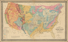
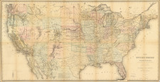
Highly detailed large format map of the United States, illustrating the extent of the public surveys conducted by the General Land Office through 1869.
This edition includes one unique territorial depiction not present in any other map we have seen, the retention of a small piece of Dakota Territory, which would become part of Montana.
Beginning in 1866, the General Land Office began issuing this remarkable large format map of the United States, full of the most up to date information from surveys being conducted throughout the western states, including the extent of the public surveys, locations of US Surveyor and Land Offices, the location of Land Grants in the west, railroads and proposed railroads, land districts, and the mineral deposits known at the end of the Civil War. With the Civil War at its conclusion and the Transcontinental Railroad construction in high gear, it was time for America to compile a visual depiction which tracked the progress of the survey, settlement and commercial development of the lands west of the Mississippi in a single map.
Between 1866 and 1870, under the auspices of the General Land Office, a series of maps was produced to accompany the annual reports of the Commissioner of the General Land Office. Initially, the maps were also widely distributed outside the United States, with copies issued as separate maps, bound in covers which translated the title into French, German and other languages, providing notice to the world that the United States was exercising dominion over all its lands from coast to coast and was a ripe place for investment and immigration.
Offered here is the next to last edition of the map, bearing the date of 1869. The 1869 and 1870 editions are the rarest on the market.
The map represents a landmark in American cartographic history and a remarkable composite of the geographical information compiled by the government up to the completion of the Transcontinental Railroad (the route being depicted as completed on the map), along with marvleous detail in the new mining regions in Colorado, Arizona, Nevada, Montana, Utah, Idaho, & Oregon.