|
||

|

|
|

|
Stock# 36797dp
Description
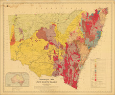
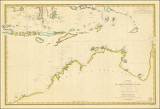
Scarce and highly detailed regional map of New South Wales and Australia Felix (Victoria)
The map, with this title, lasted for only a few years, before Australia Felix was changed to Victoria. The map provides a very early depiction of the region, pre-dating the discovery of gold.
Shows Mitchell's Route (1836) in red, Tyer's & Townsend's Route (1840) in yellow and County Streletsky's (Strzelecki) Route (1840) in blue. Extensive historical note. Decorative Piano Key border. Fine example, on thick heavy paper. From Johnston's scarce National Atlas.