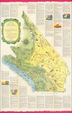
![[ La Jolla ] La Jolla Street Map By La Jolla Light](https://storage.googleapis.com/raremaps/img/small/100138.jpg)


|
||

|

|
|

|
Rare separately issued map of La Jolla, California, published by the La Jolla Light and promoting James M. Becker, a local real estate agent.
While undated, there are several clues to its date of publication:
- The La Jolla Light was first published in 1913.
- Camp Matthews (top left inset) was decommissioned in 1964.
- The Old Ardath Road is shown, prior to the creation of La Jolla Parkway in the late 1950s.
- The Salk Laboratory is shown (established 1960).
- James M. Becker arrived in La Jolla in 1952.
- The Mount Soledad Easter Cross was erected in 1954, the third such cross at this location, but the first to receive this name.
Based upon the information above, we date the map circa 1955.
The index at the bottom of the map includes several interesting historical features, including:
- Camp Matthews
- Atomic Research Lab
- Salk Laboratory
- Bishop's School For Girls
- Legion Park (on Park Row)
- Interstate 5 is still Pacific Highway (US 101)
Camp Calvin B. Matthews or Marine Corps Rifle Range Camp Matthews or Marine Corps Rifle Range, La Jolla (prior to World War II) or more simply Camp Matthews was a United States Marine Corps military base from 1917 until 1964, when the base was decommissioned and transferred to the University of California to be part of the new University of California, San Diego (UCSD) campus.
Early maps of La Jolla are rare on the market. We have never before seen this map.
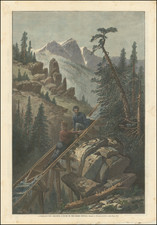
![(Southern California Oil Fields) [27 original photographs of the Kern County Oil Fields, oil derricks, oil tanks of the Pacific Coast Oil Company]](https://storage.googleapis.com/raremaps/img/small/94688.jpg)