


|
||

|

|
|

|
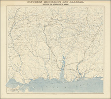
Fine uncut, unfolded example of the second edition of this rare Civil War map was created by the United States Coast Survey in 1863, under the direction of A.D. Bache.
This exceptionally detailed map was prepared specifically by the US Coast Survey for the Union Army's Campaigns in the South.
The map shows Mississippi and Alabama from Jackson to Montgomery, starting about fifty miles north of these important cities and extending south to New Orleans and the Gulf of Mexico. The map depicts the lines of important southern railroads, including
- Mississippi Central Railroad
- New Orleans & Jackson Railroad
- Southern Railroad
- Gainesville Railroad
- Alabama & Mississippi Railroad
- Mobile & Ohio Railroad
- Mobile & Great Northern Railroad (constructed in 1862)
- Mobile & Pensacolar Railroad (constructed in 1861 and removed in 1862)
- Alabama & Florida Railroad (removed in 1862)
- Alabama & Tennessee Railroad
The map also meticulously depicts the roads, towns, post offices, rivers and other important features of the region, including a Gold Mine Claim in Chilton County, Alabama, west of the Coosa River in the vicinity of Blue Creek.
There are two editions of the map, the first edition of the map, printed with two lithograhic stones, and this second edition, which adds another color. With the exception of the extra color, there is apparently no difference between the maps. Both states are very rare on the market, with only a single example listed in a dealer catalog in the past 30 years.
During the Civil War, the trained engineers and hydrographers of the United States Coast Survey played an important role in the production of field maps. While established for hydrographical mapping, at the outset of the war, it quickly became apparent that infrastructure at the Coast Survey office was the best available production site for the rapid compilation and assimilation of available cartographic sources, in order to produce maps and sea charts in aid of war being waged by the Union Army and Navy. During this time period, the Coast Survey mapmakers were also responsible for a number of printing innovations that allowed for faster and more accurate printing methods, both at home and in the field. A number of important mapmakers and other historically infuential Americans engaged in the production of maps for the Coast Survey from 1861 to 1865.
The United States Office of the Coast Survey began in 1807, when Thomas Jefferson founded the Survey of the Coast. However, the fledgling office was plagued by the War of 1812 and disagreements over whether it should be civilian or military controlled. The entity was re-founded in 1832 with Ferdinand Rudolph Hassler as its superintendent. Although a civilian agency, many military officers served the office; army officers tended to perform the topographic surveys, while naval officers conducted the hydrographic work.
The Survey’s history was greatly affected by larger events in American history. During the Civil War, while the agency was led by Alexander Dallas Bache (Benjamin Franklin’s grandson), the Survey provided the Union army with charts. Survey personnel accompanied blockading squadrons in the field, making new charts in the process.
After the Civil War, as the country was settled, the Coast Survey sent parties to make new maps, employing scientists and naturalists like John Muir and Louis Agassiz in the process. By 1926, the Survey expanded their purview further to include aeronautical charts. During the Great Depression, the Coast Survey employed over 10,000 people and in the Second World War the office oversaw the production of 100 million maps for the Allies. Since 1970, the Coastal and Geodetic Survey has formed part of the National Oceanic and Atmospheric Administration (NOAA) and it is still producing navigational products and services today.