


|
||

|

|
|

|
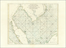
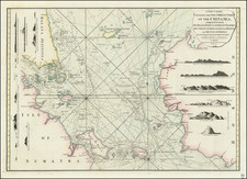
Rare English Sea Chart of the Coastline between the southern part of the Malay Peninsula, Sumatra and Borneo, including Singapore and environs, from Laurie & Whittle's rare East India Pilot.
This rare chart shows the Southern Malay Peninsula, including the island of Singapore, the Straits of Malacca, and adjacent parts of Sumatra and Borneo. Laurie & Whittle's chart represents a dramatic leap forward from contemporary maps, such as Mannevillette's treatment of the region in his Oriental Neptune, reflecting the increasing importance of the Straits of Malacca in contemporary trade routes. At the sides of the chart, 11 profile/recognition views are shown, incluing Bintang, Poolo Aore, Linging Island (Lingga), Sowra Island, and Barbe Island, among others.
The tracks of seveal voyages through the region are noted, including the Mascarin (1773), the Onslow, the L'Etoile (1775), the Vansittart (1781), and the Chameau and Elephant (1759).
A note under the Straits of Linging (Lingga) reads 'Very Little Known' and Dogger Banks are 'said to be Dangerous'. In addition to the map proper, this beautiful chart features eleven land profiles, including views of Bintang, Poolo Aore, Linging Island (Lingga), Sowra Island, and Barbe Island, among others.
This chart was especially important, for it was the map of record used by British mariners and the Royal Navy during the Napoleonic Wars. From 1811 to 1815, the British captured Malaya and much of Indonesia from the Dutch East India Company (the VOC). This chart would have been very useful to the British as they sought control of the Malacca Straits, the strategic keystone of the entire region. While the Anglo-Dutch Treaty of 1824 returned Indonesia to the Dutch, the British gained possession of Malaya and Singapore.
The chart is quite rare on the market, with no examples appearing in AMPR in the past 30 years.
Robert Laurie (ca. 1755-1836) and James Whittle (1757-1818) formed their Fleet Street, London-based firm upon the 1794 death of their employer Robert Sayer, himself one of the dominant print and mapmakers of the last half of the 18th century.
Laurie & Whittle started managing Sayer's business as early as 1787. They took over all managerial duties when Sayer's health flagged in 1792, and they changed the imprint in 1794 upon his death. Sayer left the two a 21-year lease on the shop (at £100 a year) and on Sayer's Bolt Court premises, as well as an option to acquire stock and equipment at a preferential price of £5,000 payable over three years.
Robert Laurie retired from the firm in 1812, and his role was assumed by his son, Richard Holmes Laurie (1777-1858). The younger Laurie worked with James Whittle until the latter died in 1818. After R. H. Laurie died in 1858, Alexander George Findlay, FRGS (1812-1875) purchased the firm from his daughters. The firm continues today under another name, specializing in yachting charts.
Laurie & Whittle were prolific print and map publishers, and throughout their careers, they produced numerous very important and rare works. They carried on Robert Sayer's atlas business and were responsible for editions of The Complete East-India Pilot and The American Atlas.
![[Straits of Malacca, Sumatra, Java and Western Borneo]](https://storage.googleapis.com/raremaps/img/small/51765.jpg)