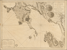


|
||

|

|
|

|
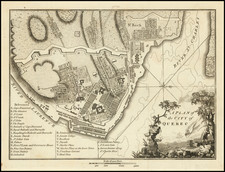
A detailed late-18th century plan of Quebec City, then the capital of British North America.
This map depicts Quebec City, founded in 1608, which remains to this day the only walled city in the Americas north of Mexico. Long the capital of New France, it was captured by the British in 1759, following the Battle of the Plains of Abraham. In 1763, it became the capital of the British Province of Quebec. In 1775, it weathered a brief siege by American Revolutionary forces.
As shown, Quebec is located on a peninsula at the confluence of the mighty St. Lawrence River and the St. Charles River. The Lower Town occupies the narrow banks below the hig precipice of Cape Diamond, atop which is the Upper Town and main part of the city. The References, or key, identifies 28 different sites throughout the city, including the various gates along the old walls, the numerous convents, churches and military installations.
The map was published by Stockdale in Isaac Weld's Travels through the States of North America.
In all, an interesting antiquarian map of one of North America's most historic cities.
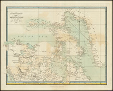

![[ Discovery of the Northwest Passage ] Chart Showing the Recent Search for a North-West Passage. Also the Coast Explored in Search of Sir John Franklin between the Years 1848 and 1854](https://storage.googleapis.com/raremaps/img/small/101874.jpg)