


|
||

|

|
|

|
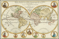
Fine example of Arnold Colom's rare double hemisphere map of the World, which appeared in his Zee-Atlas.
The map provides a fine depiction of the World. California is shown as an island, with a large landmass running due east and west to the north entitled Nova Albion, one of the only maps to provide this designation to this landmass (along with the map of his father Jacob Colom, published in 1650).
The map's treatment of Australia is noteworthy, showing only the West Coast of the Continent, but not the lands discovered by Abel Tasman and first shown by Blaeu in his wall map of 1648, and also omitting New Zealand, as well as retaining the mythical coastline of Terra Australis Incognita, as first done by Hugo Allard in 1650. South America retains its bulge. the Northern coastline of Japan is also absent.
The map is finely illustrated "with six robust statuesque figures typically representing Day and Night, and the four elements; each except for Mother Earth, proudly unclothed." (Shirley). Shirley also notes that many examples of the map ar cut off at the top, owing to the oversized plate, which was much taller than most atlas sheets of the period.
Arnold Colom was the son of Jacob Colom, a well regarded Amsterdam bookseller, printer, and chartmaker. Colom produced two sea atlases, a guide and pilot for the Mediterranean and a general sea atlas of the World. Colom's Zee Atlas, published between 1654-58, was one of the largest format sea atlases of the 17th Century, with each chart printed from an oversized copper plate. Koeman describes the atlas as "One of the most important atlases in the well known category of Dutch sea-atlases".
Apart from its rarity, the Zee-Atlas was of importance for its inclusion of the earliest Dutch sea chart of the New Netherlands to appear in an atlas (Jacob Theunisz Lootsman's chart is believed to pre-date it, but seems not to have been regularly published until later), while the "three charts of the oceans are on the same scale (1:14mill.) as Portuguese and Spanish charts of that time. It marked the first time that such charts were published as atlas sheets" (Koeman IV, p.115).
The map is of the utmost rarity and was highly influential in its time. The map was cut down slightly at the top and re-issued by Doncker and De Wit, with a reduced edition published by Meurs and re-issued by Gottfried and Vander Aa.
An exceptional example of this rare and sought after world map.
![[Early Photographic Facsimile of the 1527 Weimar Spanish World Map]](https://storage.googleapis.com/raremaps/img/small/67281.jpg)
![(World) ЗАПАДНОЕ ПОЛУШАРИЕ | ВОСТОЧНОЕ ПОЛУШАРИЕ [Western Hemisphere | Eastern Hemisphere]](https://storage.googleapis.com/raremaps/img/small/90264.jpg)
![The Western Hemisphere... [with:] The Eastern Hemisphere A Stereographical Projection on the Twentieth Meridian](https://storage.googleapis.com/raremaps/img/small/97573.jpg)