


|
||

|

|
|

|
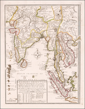
A fine example of the first printed English sea chart of the Straits of Malacca and Singapore.
This rare sea chart is one of the most historically important early maps of Singapore, southern Malaysia and the Malacca and Singapore Straits, representing the first English chart of the region. It embraces the area from a point just north of Malacca down through the Straits of Singapore to Banca Island in the Riau Archipelago, just off the northeast coast of Sumatra. The chart is oriented with the west to the top, with the Equator vertically bisecting the map. While far from being scientifically precise, the chart nevertheless has a rough plantometric accuracy, which rendered it useful to mariners, at least those sailing in decent weather. The various islands and navigational hazards are noted and depth soundings, in fathoms, demarcate the principal shipping routes.
The old trading port of Malacca, which was the first settlement in the region to fall into European hands (having been seized by the Portuguese in 1511), is located to the upper right. Further down, around the southern tip of the Malay Peninsula, is a recognizable rendering of Singapore Island, noting the 'Old Streight of Sincapore', now known as the Straits of Johor, the passage separating the island from the mainland. The modern 'Streight of Singapore' is labeled to the south of the island. Johor is itself referenced by the inclusion of the 'Riv. Johore'.
Sea chart publishing during the 17th-century had been utterly dominated by the Dutch. Amsterdam's commercial publishers maintained close relationships with the Dutch East India Company (the VOC) and merchant mariners and were able to acquire the latest hydrographic intelligence. They also had a well-developed client bases and cost-effective operations. While English printers longed to enter the sea chart market, the prospect of creating a commercially competitive product to rival the Dutch sea atlases was truly daunting.
The first Englishman to attempt to create a great international maritime atlas to rival the Dutch was John Seller (1630-1697). Seller commenced the 'English Pilot' in 1671, with his atlas volume on the 'Oriental Navigation (Third Book)' published in 1675. Unfortunately, while Seller's charts represented a major breakthrough in the history of English cartography, the project faced severe cost overruns and Seller had to discontinue the English Pilot.
Enter John Thornton (1641-1708), one of the most interesting and consequential English mapmakers of the era. Thornton was the official hydrographer to the English East India Company (the EEC) and cartographer to the Hudson's Bay Company. He had privileged access to manuscript charts from all over the world. Thornton, who was also part of the consortium backing the original English Pilot, bought some of Seller's plates and resumed the project. In 1689, he published his volume of his 'English Pilot', concerning North American and West Indies navigation. He then set his sights on acquiring source charts of Asian waters.
Thornton's efforts were aided by the accession of William of Orange to the English throne in 1689. William, who remained the regent, or Stadhouder of the Netherlands, fostered a climate in which English cartographers had easier access to Dutch sea charts. This was especially consequential for the mapping of the Malacca and Singapore Straits region, as since 1641, this area had been under the auspices of the VOC. As evidence of the transference of hydrographical information, in 1703, the Canterbury, an English East Indiaman, was captured by two French ships off of Malacca. On board were found 16 navigational charts signed by Thornton and dated 1699 to 1701. The charts contained detailed information that was otherwise thought to have been known only to the Dutch.
In 1703, John Thornton published the first edition of his English Pilot, The Third Book (Oriental Navigation), including the first state of A Large Chart Describeing ye Streights of Malacca and Sincapore. This publication proved to be quite successful, as copies were purchased by the EEC, merchant mariners and the Royal Navy. It was not long before it was considered to be the definitive coastal pilot for Asian waters by British sailors. Subsequent editions were issued after John's death, in 1711 and in 1715, by his brother Samuel Thornton (d. 1715).
Following Samuel Thornton's death, the plates were sold to Thomas Mount and William Page, who hastily issued their own edition in 1716, with the charts still bearing the Thorntons' imprint. In Mount & Page's subsequent edition of 1723, the Thorntons' imprint was erased from the cartouches, as is the case with the present chart. Further editions were issued in 1734, 1755 and finally, 1761.
The English Pilot, Oriental Navigation remained the most influential sea atlas of Asian waters used in the British Empire for almost all of most of the 18th-century. Captain James Cook was known to have taken a copy along with him on his epic Pacific voyages. While certain separately issued charts would be provide more progressive hydrographical intelligence, it was not superseded as an atlas in Britain until the publication of Laurie & Whittle's East-India Pilot, or Oriental Navigator (1797).
In spite of its great importance and influence, all issues of the A Large Chart Describeing ye Streights of Malacca and Sincapore are rare. Heavy use of the charts while at sea ensured the survival rate was quite low. Thornton's chart is foundation piece of any cartography collection of Malaysia and Singapore.
John Thornton was a respected and prominent chartmaker in London in the latter part of the seventeenth century. He was one of the final members of the Thames School of chartmakers and served as the hydrographer to the Hudson's Bay Company and the East India Company. He produced a large variety of printed charts, maps, and atlases in his career, but he was also a renowned manuscript chart maker. Born in London in 1641, he was apprenticed in the Drapers Company to a chartmaker, John Burston. After being made free of the company (1665), he was part of the combine that took over John Seller’ English Pilot in 1677. Thornton was trusted by the naval and navigational establishment of the day; one of his clients was Samuel Pepys, naval administrator and diarist. Thornton died in 1708, leaving his stock to his son, Samuel, who carried on the business.
Samuel, born in ca. 1665, also had apprenticed in the Drapers Company and was made free a year after his father’s death. He continued the business until 1715, when he died. His stock then passed to Richard Mount and Thomas Page.

![(Spice Islands) A New Chart of the Banda Sea, Including The Isles of Amboyna, and Banda, Those of Bouro, Ceram and The Circumjacent Islands; with the N.E. End of Timor . . . [with inset maps of Bay of Amboyna and Islands of Banda, Goonong-Appee and Banda Neira]](https://storage.googleapis.com/raremaps/img/small/97002.jpg)