|
||

|

|
|

|
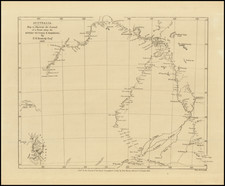
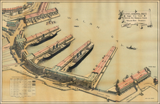
Nice example of the 1858 edition of the first nautical chart of Port Phillip, originally published by the British Hydrographical Office in 1836.
The chart corresponds to the earliest settlement of Melbourne and the Port Phillip area, having first been prepared on the same trip that delivered Captain William Lonsdale to Port Phillip to assume command of the region.
The chart shows lighthouses, soundings, channels, sand shoals, swamps, mountains and other coastal features, with a larger inset map of the entrance to the bay.
In 1797, George Bass became the first European to enter Bass Strait, the passage between the Australian mainland and Van Diemen's Land (Tasmania). In 1802, John Murray in the Lady Nelson entered Port Phillip, followed shortly thereafter by Matthew Flinders.
In 1803, Charles Grimes, the deputy surveyor-general of New South Wales, traveled to Port Phillip to conduct the first official survey. He found the area inhospitable and recommended againsta settlment. Despite his recommendations, fearing that the French would attempt to settle the area, the Governor of New South Wales sent Colonel David Collins with a party of 300 convicts to establish a settlement at Port Phillip at the site of the present day Sorrent. Finding a lack of fresh water, in May 1804, Collins moved the settlement to Tasmania, establishing Hobart.
In 1824, Hamilton Hume and William Hovell traveled overland to Corio Bay, where they found good grazing land. But it was another ten years before Edward Henty, a Tasmanian grazier, established an illegal sheep-run on crown land at Portland, in what is now western Victoria, in 1834. John Batman, a successful farmer in northern Tasmania, also desired more grazing land. He entered Port Phillip Bay in May 1835, landing at Indented Head. He explored the area around the Bay, incuding the area north of Melbourne.
Batman and John Pacoe Fawkner both had designs on settling Port Phillip in 1835 and began to settle in the area. In September 1836, the Port Phillip District was established, with Captain William Lonsdale appointed as the first head of the region. Lonsdale arrived at Port Phillip on board HMS Rattlesnake. They anchored at the south end of the Bay on September 27 1836, where Hobson sent out a smaller boat to conduct survey work, which marked the commencement of the work in the creation of this chart.
Among the British Naval Officers contributing to the chart were Commander J.C. Wickham and Captain Stokes. John Lort Stokes (1812-1885), while serving as Lieutenant and later a Captain, participated in a broad survey of Australian coasts and waters conducted on HMS Beagle under the command of John Clements Wickham whose illness led to Stokes being given the command of the Beagle and the responsibility for the survey the following year. Upon his return to England, Stokes wrote a popular account of the survey Discoveries in Australia, with an account of the coasts and rivers explored and surveyed during the voyage of the Beagle, 1837-1843 which was published in 1846.
The British Admiralty has produced nautical charts since 1795 under the auspices of the United Kingdom Hydrographic Office (HO). Its main task was to provide the Royal Navy with navigational products and service, but since 1821 it has also sold charts to the public.
In 1795, King George III appointed Alexander Dalrymple, a pedantic geographer, to consolidate, catalogue, and improve the Royal Navy’s charts. He produced the first chart as the Hydrographer to the Admiralty in 1802. Dalrymple, known for his sticky personality, served until his death in 1808, when he was succeeded by Captain Thomas Hurd. The HO has been run by naval officers ever since.
Hurd professionalized the office and increased its efficiency. He was succeeded by the Arctic explorer Captain William Parry in 1823. By 1825, the HO was offering over seven hundred charts and views for sale. Under Parry, the HO also began to participate in exploratory expeditions. The first was a joint French-Spanish-British trip to the South Atlantic, a voyage organized in part by the Royal Society of London.
In 1829, Rear-Admiral Sir Francis Beaufort was appointed Hydrographer Royal. Under his management, the HO introduced the wind force scale named for him, as well as began issuing official tide tables (1833). It was under Beaufort that HMS Beagle completed several surveying missions, including its most famous voyage commanded by Captain FitzRoy with Charles Darwin onboard. When Beaufort retired in 1855, the HO had nearly two thousand charts in its catalog.
Later in the nineteenth century, the HO supported the Challenger expedition, which is credited with helping to found the discipline of oceanography. The HO participated in the International Meridian Conference which decided on the Greenwich Meridian as the Prime Meridian. Regulation and standardization of oceanic and navigational measures continued into the twentieth century, with the HO participating at the first International Hydrographic Organization meeting in 1921.
During World War II, the HO chart making facility moved to Taunton, the first purpose-built building it ever inhabited. In 1953, the first purpose-built survey ship went to sea, the HMS Vidal. Today, there is an entire class of survey vessels that make up the Royal Navy’s Hydrographic Squadron. The HO began to computerize their charts in the late 1960s and early 1970s. In 1968, the compilation staff also came to Taunton, and the HO continues to work from there today.
![Isles de Salomon [Early depiction of New Zealand!]](https://storage.googleapis.com/raremaps/img/small/101683.jpg)