This item has been sold, but you can enter your email address to be notified if another example becomes available.


|
||

|

|
|

|
Stock# 35661mb
Description
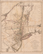
Well used example of Mark Tiddeman's important early chart of New York Harbor.
Tiddeman's chart of New York Harbor shows the area between Sandy Hook and Westchester with part of Long Island. The chart kncludes the Rariton River, Staten Island, Amboy, Elizabeth Town, Newark, Bergen, Manhattan, Harlem, Gravesend, Redhook, Flatbush, New Town and Flushing. The chart details the difficulties of maneuvering ships in the harbor though it also reveals New York's excellent port location. North is oriented to the right.
This chart, first published in "The English Pilot" (Book Four) circa 1732, was at that time the only printed chart of the area available. Although it is highly inaccurate, it was published without significant alterations, for 60 years.
Condition Description
Trimmed to the neat line, with new margins expertly added. Several areas of facsimile work in manuscript.

![[ Cape Hatteras to New York City ] The Coast of the United States of North America; from New York to St. Augustine: Drawn and regulated according to the latest Surveys and Astronomical Observations By Edmund Blunt. Additions to 1839 & 1840](https://storage.googleapis.com/raremaps/img/small/84684.jpg)