|
||

|

|
|

|
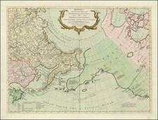
Fine old color example of Hendrick Doncker's sea chart of the Pacific Ocean, extending from Australia, New Zealand and Japan to California.
As noted by Brian Hooker, "Doncker's chart is the earliest printed work to include a section assigned to a part of New Zealand."
Doncker's chart is among the earliest regioal maps to focus on the Dutch discoveries in New Zealand and Australia. Van Diemen's explorations in Australia of 1642 are noted and dated, as is a note regarding the discovery of New Zealand in 1642. Many other islands are noted, as is Japan, with a curious depiction of its northern islands.
Across the Pacific Ocean, Californai and the Straits of Anian are plainly depicted.
For about fifty years Hendrick Doncker ran a flourishing business in Amsterdam as a publisher of sea atlases and textbooks on navigation. In a period when so many maps and charts were simply copied from other publishers, Doncker's charts were his own work and were noted for their accuracy and constant improvement. Apart from this work, he cooperated for many years with Pieter Goos and Anthonie Jacobsz in producing a pilot guide De Zeespiegel.
Hendrik Doncker was a prominent bookseller in Amsterdam best known for his sea charts and nautical atlases. He issued his own original charts, which he updated frequently, and also worked with colleagues like Pieter Goos, for example to produce the pilot guide, De Zeespeigel. He died in 1699, after fifty years in business. His plates then passed to Johannes van Keulen.
![[ Huntington Beach Infrastructure Map -- Newport Beach to Long Beach ]](https://storage.googleapis.com/raremaps/img/small/98369.jpg)
![(Southern California) Utazás Kalifornia Déli Részeiben [Travel in Southern California] [with map:] Kalifornia déli részei Legújabb kútfök után szerkesztette es rajzolta. [Southern parts of California Edited and drawn after the latest sources.]](https://storage.googleapis.com/raremaps/img/small/92022.jpg)