|
||

|

|
|

|
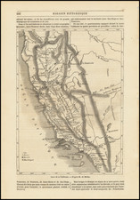
A Manuscript Ranch of John Sutter's Lands
Manuscript plat map of the area from Sacramento to Yuba City, Marysville and the Yuba River, illustrating John A. Sutter's fabled Rancho New Helvetia on the Feather River.
The map locates Sacramento, Yuba City and Marysville, as well as a number early Ferries across the Feather River, Yuba River, American River and Sacramento River. A Butterfield Stage location is shown, as are other points of interest along the rivers, including a Water Works on the Sacramento River, Five Mile House on the American River, an Indian Reservation on the Feather River, a house in Eliza Town (established 1850, but abandoned shortly thereafter) on the Feather River, a bridge across the Feather River at Yuba City and across the Yuba River above Marysville, etc. Several early roads are also located.
The survey of Sutter's Rancho was made as part of the proceeding to establish the validity of Sutter's Spanish Land Grant, made by the Mexican Governor of California to Sutter in 1841 and originally confirmed to Sutter in 1857. However, the US Attorney General challenged the grant, which was not resolved until 1866.
The present map would seem to be an early draft of the final Plat map. Two examples of the final Plat map are in the collection of the University of California, Berkeley. The later editions credit E.H. Dyer, Depy. Survr. and contain notes through 1863. The present map references several parcels of land which were included in earlier surveys of the Rancho, but not included in Von Schmidt's final survey. The present maps includes information not in the final version, including the Butterfield location on the Feather River and the location of the "Old Ford" on the Feather River and the location of several of the Ferries.
The present plat came out of the files of B.F. Leete, a surveyor who came to California in 1858. Leete was employed for a time by Theodore Judah, an early advocate of the intercontinental railroad, before venturing on to Nevada and establishing the Eagle Salt Works. While the origin of the map is unknown, certainly dates from before 1862, when Leete seems to have left Sacramento permanently, as noted in the annotation in the lower left corner.
A.W. Von Schmidt was a surveyor trained in his native Prussia, who came to California in 1849. Von Schmidt worked for the US Surveyor General, mapping public lands and Spanish land grants throughout the state, before becoming a controversial figure in the California and Nevada's water wars.
![[Native American Indians in Southern California] Native Sites in Part of Southern California](https://storage.googleapis.com/raremaps/img/small/102006.jpg)
![[California] Honor Roll Foresters of America May 1, 1947 to May 1, 1948](https://storage.googleapis.com/raremaps/img/small/63016.jpg)
![California Wine Land of America [Sauterne, Burgundy]](https://storage.googleapis.com/raremaps/img/small/93654.jpg)