|
||

|

|
|

|
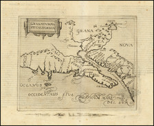
A large-format map of the coasts of Northern California and Oregon from the epic voyage of the Jean-François de Galaup, Comte de La Pérouse, becoming the first non-Spaniards to visit Spanish Colonial California.
This fine map embraces the West Coast from Monterey, California to up a point in Oregon just south of the mouth of the Columbia River. The map shows the taracks of La Pérouse's ship along the coastline of California in September 1786, one of the earliest non-Spanish expeditions to make detailed observations along the coastline of California in the 18th Century. The account of the voyage is notable for its inclusion of harbor charts of San Francisco, Monterey and San Diego Bays, although this chart does not show La Perouse's ships entering San Francisco Bay.
Jean-François de Galaup, Comte de La Pérouse (1741-88) was a French naval officer and scientist. In response to Cooks's epic Pacific Voyages (1768-80), the French government appointed La Perouse to lead an expedition to explore the regions that were left uncharted by Cook.
In 1785, La Pérouse's party set out in two ships, the Astrolabe and the Boussole. La Pérouse explored Hawaii (being the first European to set foot on Maui), the coasts of the Gulf of Alaska and northwestern North America in search of the fabled Northwest Passage. Subsequently, he explored East Asia from Kamchatka to Macao, before heading to the Solomon Islands in the South Pacific. His expedition vanished shortly after leaving Botany Bay, Australia, in 1788. Fortunately, before setting off, La Pérouse left his manuscript maps and journals with the British in Australia, thus allowing the present chart to be published, for the first time, almost a decade later.
La Pérouse was the first non-Spanish visitor to California since Drake's visit in 1579, and the first to come to California after the founding of the Spanish missions and presidios. As depicted on the map, during August and September 1786, La Pérouse sailed as far south in America as the Spanish region of Alta California (present-day California). He reportedly observed the only historical eruption of Mount Shasta on September 7, 1786, although this account is disputed. He stopped in San Francisco long enough to create an outline map of the Bay Area, which is incorporated into the present chart. He arrived at the Presidio of Monterey on September 14, 1786.
![[Native American Indians in Southern California] Native Sites in Part of Southern California](https://storage.googleapis.com/raremaps/img/small/102006.jpg)