|
||

|

|
|

|
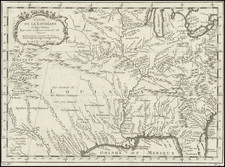
Nice early eample of Colton's map of Wisconsin.
Wisconsin became a Territory in 1836 and a state in 1848. The maps shows several counties whose name would later change, Bad Ax (Vernon) and LaPointe (Bayfield). A number of the Northern Counties are still not formed. Decorative borders and an inset of Milwaukee.
G. W. & C. B. Colton was a prominent family firm of mapmakers who were leaders in the American map trade in the nineteenth century. The business was founded by Joseph Hutchins Colton (1800-1893) who bought copyrights to existing maps and oversaw their production. By the 1850s, their output had expanded to include original maps, guidebooks, atlases, and railroad maps. Joseph was succeeded by his sons, George Woolworth (1827-1901) and Charles B. Colton (1831-1916). The firm was renamed G. W. & C. B. Colton as a result. George is thought responsible for their best-known work, the General Atlas, originally published under that title in 1857. In 1898, the brothers merged their business and the firm became Colton, Ohman, & Co., which operated until 1901, when August R. Ohman took on the business alone and dropped the Colton name.

![A Map of Lewis and Clark's Track Across the Western Portion of North America, from the Mississippi to the Pacific Ocean. By Order of the Executive of the United States in 1804, 5 & 6. . . . [Complete with 3 volumes of Text: Travels to the Source of the Missouri River and Across the American Continent to the Pacific Ocean. Performed by Order of the Government of the United States, in the Years 1804, 1805, and 1806].](https://storage.googleapis.com/raremaps/img/small/81775.jpg)