This item has been sold, but you can enter your email address to be notified if another example becomes available.


|
||

|

|
|

|
Stock# 35013
Description
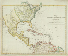
Rare (unrecorded) map of the United States and the Caribbean, one of the earliest maps to use the name "Etats Unis" (United States).
While it is not possible to date the map based upon the cartographic information shown, the failure to name Maine, Vermont, Ohio or the Northwest Territory and the failure to make a definitive delineation of the boundaries of th United States strongly points to a date around 1780, prior to the Treaty of Peace which settled the American Revolution.
This is the first time we have seen this map.
![[ Atlas of The United States ] Karte von Amerika](https://storage.googleapis.com/raremaps/img/small/84353mp2.jpg)
![Charte von Den Vereinigten Staaten von Nord-America nebst Louisiana . . . 1805 [Rare 1st State of Gussefeld's Louisiana Purchase Map]](https://storage.googleapis.com/raremaps/img/small/63496.jpg)