


|
||

|

|
|

|
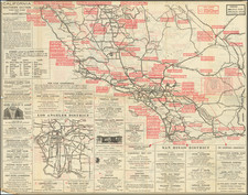
Rare sea chart of California, Mexico and Central American coastline, showing the southern sea route to San Francisco printed on the eve of the California Gold Rush.
This fine chart depicts the length of the Pacific Coast of North and Central America, from the Gulf of Dulce in Costa Rica up to San Francisco Bay, California. The main section of the chart shows the coast from Costa Rica up to the port of San Blas, Nayarit, Mexico. In the latter 18th-century, San Blas was importantly the base for Spanish Pacific explorers. Indeed, the tracks of Captain Alejandro Malaspina's 1791 southward voyage, commanding the Descubierto and the Atrevida, is delineated on the map. The large inset to the left features the coastline from San Blas northwards to include San Francisco Bay.
The inset to upper center, Harbour of Monterey. Surveyed by the Officers of the U.S.S. Dale. T.A. Dornin, Commander. 1843, details the recent American survey conducted of the bay which lay before Monterey, then the capital of the Mexican state of Alta California.
The inset in the upper right features The Harbour of San Francisco. Surveyed by Capt. F. W. Beechey, R.N., and depicts the masterly survey of San Francisco Bay conducted by the British hydrographer in 1826. From 1825-8, the British Admiralty dispatched the Captain Frederick William Beechey to conduct an epic Pacific Voyage, which was in part meant to search for a western route into the Northwest Passage, but also to map harbors of strategic interest. Neal Harlow, in his article 'The Maps of San Francisco Bay and the Town of Yerba Buena', wrote that:
"Beechey had been instructed [by the British Admiralty] before undertaking the expedition to make careful surveys in the Pacific where such had not been previously completed, and his men were constantly engaged in this business at San Francisco during the 1826 visit. Under Beechey's direction they examined in two months' time the portions of the harbor which he felt were most likely to be frequented by vessels for years to come.... Following the publication of the Beechey chart in 1833, it became the authoritative guide to the bay and remained so until well into the American period.... It became the source of a long line of copies and adaptations."
The present chart, printed in New York by the leading firm of E. & G.W. Blunt, was published on the eve of the California Gold Rush and near the end of the Mexican-American War (1845-8), which gave the U.S. possession of Upper California (which would become the state of California in 1850). Apart from the mapping of the bays of San Francisco and Monterey, the coasts of California had never been scientifically charted, while American awareness of Spanish and Mexican surveys of the coasts of Mexico and Central America was limited. In 1848, the area of the Pacific featured on this map occupied a critical corridor for thousands of migrants sailing to California in search of riches yielded by placer gold. Many migrants' vessels sailed from the Atlantic around Cape Horn and up into these waters, while other migrants boarded ships in Mexico and Central America, after crossing the continental isthmus by land.
The Blunt firm issued this chart using the best available sources in order to service shipping in this critical corridor. It would remain one of the most American navigational chart used during the height of the Gold Rush, eventually superseded by charts produced by the U.S. Coast and Geodetic Survey, which were published from 1853 onwards.
The present chart is rare. We are aware of only 2 other examples appearing on the commercial market in the last 25 years and we can locate only 3 examples in institutional collections (Berkeley, Huntington and Yale Sterling). Yale also holds an 1849 edition of the chart.

![(Mexican-Aztec Paintings) Facsimile, page 19 of an original [Mex]ican painting of Sir Thomas Bodley's collection [in the Bod]leian Library, Oxford, [Aglio's] Antiquities, vol. 1](https://storage.googleapis.com/raremaps/img/small/102328.jpg)

![Tunison's California, Oregon and Nevada [Yosemite Valley & Big Trees Vignettes]](https://storage.googleapis.com/raremaps/img/small/92845.jpg)