|
||

|

|
|

|
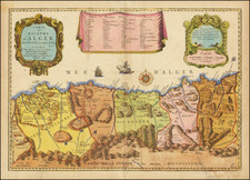
Authoritative chart of the coast of Algeria, issued by the Ministre de la Marine immediately after France established colonial rule of the region.
The present sea chart depicts the central portion of the coast of Algeria, centered on the Bay of Algiers. In 1830, France placed its colonial claim upon Algeria and government officials immediately realized that obtaining advanced geographic and hydrographic intelligence on the country was an imperative.
In 1831, Lieutenant Auguste Bérard, the master of the brig La Lorient and the hydrographer Louis Urbain Dortet de Tessan, were given the vital task of charting the waters around the capital, Algiers. The chart is based on exacting trigonometric surveys and shows coastal topography in delicate relief, as well as numerous bathymetric soundings. It remained the authoritative chart of these waters for several decades.
This chart is scarce, we are not aware of an example appearing on the market in the last 25 years.
The Dépôt de la Marine, known more formally as the Dépôt des cartes et plans de la Marine, was the central charting institution of France. The centralization of hydrography in France began in earnest when Jean-Baptiste Colbert became First Minister of France in 1661. Under his watch, the first Royal School of Hydrography began operating, as did the first survey of France’s coasts (1670-1689). In 1680, Colbert consolidated various collections of charts and memoirs into a single assemblage, forming the core of sources for what would become the Dépôt.
The Dépôt itself began as the central deposit of charts for the French Navy. In 1720, the Navy consolidated its collection with those government materials covering the colonies, creating a single large repository of navigation. By 1737, the Dépôt was creating its own original charts and, from 1750, they participated in scientific expeditions to determine the accurate calculation of longitude.
In 1773, the Dépôt received a monopoly over the composition, production, and distribution of navigational materials, solidifying their place as the main producer of geographic knowledge in France. Dépôt-approved charts were distributed to official warehouses in port cities and sold by authorized merchants. The charts were of the highest quality, as many of France’s premier mapmakers worked at the Dépôt in the eighteenth century, including Philippe Bauche, Jacques-Nicolas Bellin, Rigobert Bonne, Jean Nicolas Buache, and Charles-François Beautemps-Beaupré.
The Dépôt continued to operate until 1886, when it became the Naval Hydrographic Service. In 1971, it changed names again, this time to the Naval and Oceanographic Service (SHOM). Although its name has changed, its purpose is largely the same, to provide high quality cartographic and scientific information to the France’s Navy and merchant marine.
![Africae II Tab [Shows Malta, Sicily and Sardiia]](https://storage.googleapis.com/raremaps/img/small/78022.jpg)
![(Marakesh) Palatium Magni Regis Maroci In Barbaria [Palace of the Great King of Morocco in Barbary]](https://storage.googleapis.com/raremaps/img/small/53154.jpg)