|
||

|

|
|

|
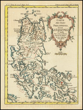
A rare sea chart, including a map of Manila Bay, Philippines, accompanied by a chart and view of Côn Son Island, Vietnam, which appeared in the rare first edition of Mannetvillettes's Le Neptune Oriental, published in 1745.
The chart is one of the earliest obtainable detail charts of Manilla Bay.
The chart of Manila Bay, that occupies the upper half of the composition, is orientated with an eastward perspective, and embraces the entire coastal area from Cavite to the city of Manila and as far north as Subic Bay. It is based on the most progressive sources available to the French Navy, and the overall depiction of somewhat similar to that featured on the Jacques Nicolas Bellin's contemporary charts. European interest in Manila Bay, and the Philippines in general, was heightened upon hearing news of British Admiral George Anson's capture of a Spanish Manila Galleon off of Cabo Espiritu Santo in 1743.
Below, the composition features an attractive view and map of the Isle de Condor (Côn Son Island). Strategically located off the southern tip of Vietnam, this safe anchorage had long been favored as a hideaway by pirates, and more recently as a victualing point by European traders. In 1702, the English East India Company built a short-lived fort on the islands, designated on the current map as "Fort Anglois ruiné". The French also harbored designs on the island, and in 1787, Côn Son was ceded to France by Vietnam.
The present chart was drafted by Jean-Batiste de Mannevillette (1707-80), and engraveded on copper by the master engraver Guillaume Dheulland. Mannevillette apprenticed under the great royal cartographer Guillaume De L'Isle. He then joined the maritime service of the Compagnie des Indes, eventually attaining the rank of captain. Upon his return to Paris, Mannevillette was appointed as director of the Dépôt des Cartes et Plans de la Navigation des Indes. In 1745, he published the first edition of his sea atlas of Asian waters, Le Neptune Oriental. While not included in the atlas, it seems that the production of the present chart was closely associated with this project. The high quality of Mannevillette's charts won him the acclaim of both mariners and academics alike, and he was admitted as a fellow of the Academy of Sciences. He published a second, heavily revised, edition of the Neptune Oriental in 1775.
Jean-Baptiste Nicolas Denis d’Après de Mannevillette (1707-1780) was a French sailor and hydrographer celebrated for his excellently-rendered charts. Mannevillette was born into a maritime family and he joined his father on a French East India Company voyage to India aged only twelve. A clever boy, he returned to France to study navigation, chartmaking, and mathematics with Joseph-Nicolas De L’Isle. At nineteen, he was back at sea, working his way up the ranks of the French East India Company’s merchant fleet.
In his work with the company—he was eventually promoted captain—Mannevillette sailed to the Indian Ocean many times. En route, he was constantly gathering and correcting hydrographic knowledge. He was also skilled at using the latest navigational instruments, like the octant and later the sextant, which allowed him to make his charts especially accurate for their time. He compiled his work into his most significant publication, Le Neptune Oriental, which was commissioned by the French East India Company and first published in 1745. It was released in an expanded second edition in 1775, with posthumous expansions in 1781 and 1797.
The Neptune earned Mannevillette many accolades. The company made him Director of Charts at Lorient in 1762. In 1767, King Louis XV gave him the Order of St. Michael and named him an associate of the Royal Marine Academy.
![[Philippine Islands, Taiwan, etc] Partie des Isles Philippines; Partie de la Chine; Partie de L'Ile Gilolo; Partie de L'Isle Borneo](https://storage.googleapis.com/raremaps/img/small/93579.jpg)
![[Elephants & Tourism] Chaine Des Elephants Plateau Du Bo'kor [Southeastern Cambodia]](https://storage.googleapis.com/raremaps/img/small/64472.jpg)