|
||

|

|
|

|
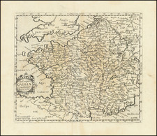
One of the first maps of France printed in England.
This attractive map of France was printed in London, as part of Richard Blome's Geographical Description Of Four Parts Of World (1670), one of the first commercially successful English atlases. The depiction of France is taken from the mapping of Nicolas Sanson (1600-67), the French royal geographer, and depicts France at the height of the power of the 'Sun King' Louis XIV. Each of France's provinces is outlined in vibrant, typically English, original color, including the regions in modern Belgium recently acquired by France during its recent war against Spain. This map would have been of great interest to the English public, as many would have been curious about the nature of their country's perennial military antagonist. The composition is beautifully adorned with the arms of the map's dedicatee, Sir Justinian Isham, which is surmounted by a swan.
Richard Blome (1635-1705) was a preeminent force in the great resurgence of English cartography and publishing that accompanied the Caroline Restoration. A highly enterprising businessman, he continually sought out the latest geographical intelligence and employed London's leading engravers to execute his publications. In addition to the Geographical Description Of Four Parts Of World, first issued in 1669 (with later editions entitled as the Cosmography and Geography), Blome notably published Britannia (1673), the third part of his atlas project, detailing the 'Sceptred Isle'. He also issued an important work on England's growing New World Empire, The Present State of His Majesties Isles and Territories in America (1687).
![[Duke of York's Copy] Le Toulois ou sont Les Chatellenies et Les Prevotes du Temporel de l'Eveche de Toul et de son Chapitre; Partie du Balliage de l'Eveche de Verdun. Le Duche de Barrois ou Balliage de Bar le Duc . . .](https://storage.googleapis.com/raremaps/img/small/71292.jpg)
![[Ptolemy's France] Europ III Tab](https://storage.googleapis.com/raremaps/img/small/89187.jpg)