|
||

|

|
|

|
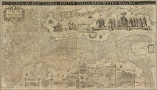
The only known example of the first scientific general chart of the Mediterranean Sea and the earliest known map to feature all of Admiral William Henry Smyth's surveys.
William Henry Smyth's A New Chart of the Mediterranean Sea was the first general chart of this entire maritime realm to be largely based on scientific surveys. One of the great landmarks of the era of 'Blueback Charts', the present map is importantly the earliest known chart to includes all of the Smyth's Mediterranean surveys on a single work, as well as those by other leading cartographers such as Sir Francis Beaufort. Finely engraved, including numerous insets of harbors, this chart and the editions that followed it, served as the hydrography of record for the Royal Navy during the critical period when it consolidated Britain's military and political influence within the Mediterranean Sea. In spite of the pioneering significance of the present chart, it is truly remarkable that it is entirely unrecorded, and known only in this single example.
The chart embraces the entire Mediterranean Sea, from the Pillars of Hercules at the Strait of Gibraltar, all the way to its easternmost reach, the Gulf of Iskenderun. The monumental size of the chart affords a great level of detail and precision, with virtually every significant harbor being labeled, and major points of coastal relief expressed through delicate shading. Rhumb lines traverse the sea, and numerous depth soundings dot key corridors of passage.
Aiding its practical utility, the chart is surrounded by 19 finely engraved cartographic insets, including: Carthagena (Spain), Bay of Gibraltar, The Strait of Gibraltar by [Don Vincente] Tofino, Environs of Marseille, Messina (Italy), Bay of Naples, Palermo, Trieste, Alexandria, The Gulf of Smyrna (Izmir, Turkey), The Maddalena Islands and the Strait of Bonifacio by Captain T. Rogers (Sardinia and Corsica), Corfu, Gulf of Palma (Sardinia), Valetta (Malta), The Maltese Islands, Genoa, The Roads… of Livorno or Leghorn (Italy), Harbor of Malaga, Bay of Algier[s] (Algeria). In the lower-right corner the map also features a shoreline panorama of 'Yaffo, or Jaffa' (Israel).
The Napoleonic Wars and the Need for Accurate Charts
Smyth's surveys and the publication of his charts coincided with the rise of Britain as the premier naval power in the Mediterranean Sea. While the Royal Navy had maintained a fixed presence in the region since it seized Gibraltar in 1704, it was only during the Napoleonic wars (1796-1815), that Britain became the dominant maritime power in the region, having decisively defeated the French Navy.
The charts of record used by the Royal Navy during the Napoleonic Wars were William Heather's A New Chart of the Mediterranean Sea (1797), and the regional charts contained in Heather's The New Mediterranean Pilot (1802). While Heather made conscientious efforts to provide a high quality product, and was assisted by the Navy in regularly updating his publications, the reality was he had only highly variable access to hydrographic intelligence, as it was often not possible for the British to survey the shores of foreign (and often antagonistic) nations. Thus, during the conflict, British commanders were often frustrated by the uneven quality of the coverage featured on Heather's charts. While the hydrography copied from charts by the French Dépôt de la Marine and the Spanish master Don Vincente Tofiño de San Miguel was impressively accurate, elsewhere the charting of large expanses of coastline, such as Turkey and North Africa, was severely imprecise. It was only when the wars had concluded that surveyors from a victorious Britain were free to chart the shores of Mediterranean with a full measure of scientific acumen, endeavors that was entrusted to Smyth and his colleagues.
William Henry Smyth, R.N.: Master Hydrogapher
William Henry Smyth (1788-1865), often called "Mediterranean Smyth" was one of the most important hydrographers of his era, and subsequently became a leading member of the scientific community in London. Smyth went to sea at the age of 14, joining the crew of the Cornwallis, an East India merchantman. Shortly thereafter the Cornwallis was impressed into service with the Royal Navy, and aboard Smyth saw service in China, India and Australia, before returning to the European theater. In 1810, he received his first command when he became skipper of a Spanish gunboat, Mors et Gloria, during the defense of Cadiz. He subsequently joined the HMS Rodney off of Toulon, before returning to the coasts of Spain.
In March 1813, Smyth was promoted to the rank of lieutenant and posted to the Sicilian flotilla. While not engaging the French in battle, Smyth had the opportunity to conduct informal surveys of the coastlines and explore his love of antiquities and archaeology. Following the end of the war, in the summer of 1815, Smyth was promoted to commander, and placed in charge of the HMS Scylla. His highly accurate and beautifully drafted manuscript charts of Sicily so impressed the Admiralty that Smyth was officially charged with conducting advanced trigonometric and hydrographic surveys of the coasts of southern Italy and Tunisia. Ever the skillful diplomat, he forged close relationships with Austrian and Neapolitan surveyors that allowed him to complete the first scientific survey of the coasts of the Adriatic Sea, which were subsequently published as the Carta di Cabottaggio del Mare Adriatico (1822-24).
In 1817, Smyth was placed in command of the HMS Aid, a ship which was later renamed the HMS Adventure, and would become famous for accompanying the HMS Beagle on Charles Darwin's first overseas voyage. For the next seven years, Smyth greatly expanded his surveying activities, charting the coasts of northwestern Italy, Greece, Libya and Egypt. Beginning in 1821, his various regional charts were printed in London by the Admiralty, with many being compiled into an atlas, The Hydrography of Sicily, Malta, and the adjacent Islands (1823).
Attaining the rank of Rear Admiral in 1825, Smyth retired from active naval service, and dedicated the rest of his career to the pursuit of scientific and literary ventures. Returning to England, he established an observatory at Bedford, and his work in astronomy won him the Gold Medal of the Royal Astronomical Society. He also served as President of the Royal Geographical Society and was a foremost authority on numismatics. When Smyth died in 1865, he was hailed as one of the most respected and beloved intellectuals in Britain.
The Story of the Production of the Present Chart
Following the conclusion of Smyth's surveying endeavors the Admiralty decided that it was an imperative to produce a new and accurate general chart of the Mediterranean to replace Heather's work. Smyth had produced masterly surveys of Sicily, Sardinia, Malta, the coasts of mainland Italy and the Adriatic, much of Greece, as well as the coasts of Algeria, Tunisia, Libya and Egypt. Together, these embraced almost all of the coastlines of the central Mediterranean. To complete the picture, the Admiralty drew upon the fine surveys of the coasts of Turkey by Admiral Sir Francis Beaufort (1811-12), surveys of the coasts of France and Israel by the French Dépôt de la Marine, as well of surveys of the coasts of Spain and Morocco by the Spanish Armada Real. While there were a few minor gaps in the coverage of scientific surveys, the Admiralty had enough information to create what could be considered to be the first broadly accurate general chart of the Mediterranean Sea based on scientific surveys.
The Admiralty's issued A Chart of the Western Division of the Mediterranean Sea. By Capt. W.H. Smyth ... between the years 1814 & 1824 (1825). This chart is known in only a single example, held by the British Library, and extends to include the western two-thirds of the Mediterranean (ending it coverage in the east as far as Crete). No example of the supposed chart of the 'Eastern Division' has come to light, meaning that the present chart is the earliest complete general chart of the Mediterranean embracing all of Smyth's surveys.
While no date or imprint appears on the present chart, it would appear that it was likely published by R.H. Laurie in London, and issued either in 1826 or early 1827. Below the title appears a small inscription noting that this chart was available for purchase "With or without this chart may be had The New Sailing Directory for the Mediterranean Sea, The Adriatic Sea, lately published by Laurie", referring to a book of sailing directions compiled by John Purdy, published by R.H. Laurie in 1826. The style of engraving is very much in line with other charts produced by R.H. Laurie of 53 Fleet Street, London. The firm, formerly called Laurie & Whittle, was headed by Robert Laurie (1755-1836), and had been one of Britain's leading publishers of charts for over thirty years. Laurie had privileged access to the Admiralty's manuscript surveys, so it is no surprise that he was able to compile this magnificent general chart. While Laurie often received official publishing permission granted by the Admiralty, in this particular case, it is not clear as to whether the present chart is an officially sanctioned issue.
Conclusions
Smyth's A New Chart of the Mediterranean Sea (1826/7), known only in the present example, was the first broadly scientific general chart of the entire Mediterranean, and the earliest map to embrace all of Smyth and Beaufort's epic surveys. The hydrographic information it contained formed the basis for all of the best sea charts of the region during the succeeding decades. Another version of the chart, completely re-engraved with entirely different insets, was issued by Robert & William Blachford, as Blachford's New Chart of the Mediterranean Sea, Adriatic Archipelago & Black Sea from Surveys of Capt. W.H. Smyth (1828), with another edition appearing in 1849. Smyth and Beaufort's survey were also incorporated inter alia, or without attribution, on numerous other commercially produced charts, as well as official issues published by the Admiralty's United Kingdom Hydrographic Office (U.K.H.O.).
Throughout the 19th-century, these surveys played a highly important role in the growing projection of British maritime power, and in the greater events which that effected the course of Mediterranean history. Free of serious competition in the naval sphere, Britain acquired an archipelago of naval bases throughout the region, including Malta (1814), the Ionian Islands (1815), Cyprus (1878) and Alexandria, Egypt (1882). Importantly, the present chart appeared during the middle of the Greek War of Independence (1821-32), and right before the decisive naval Battle of Navarino (October 20, 1827), during which the Royal Navy helped Greece to gain her freedom from Ottoman rule. The Smyth and Beaufort surveys also helped to guide the Anglo-French forces on their way to the Black Sea during Crimean War (1853-6). Few other surveys from the great era of 'Blueback Charts' played such a consequential role in history.
Richard Holmes Laurie (1777-1858) was the son of mezzotint engraver Robert Laurie, who had taken over Robert Sayer's publishing house with James Whittle in 1794. Richard Holmes Laurie joined in a partnership with Whittle when his father retired in 1812. The name of the firm then switched from Laurie & Whittle to Whittle & Laurie. Whittle died in 1818, leaving Richard Holmes to continue publishing alone as R. H. Laurie.
When the Hydrographic Office opened in 1795, it was tasked with creating and producing all the nautical charts for the Royal Navy so as to wean the Navy off dependence on foreign charts. By the 1820s, private publishers were augmenting HO charts and competing with them, including Richard Holmes Laurie. Richard gave up publishing anything except nautical materials by 1830. He also sold charts to Trinity House, the lighthouse and maritime safety fraternity. He died in 1858.
The firm continued to print under the name R.H. Laurie even after 1858. Later, the firm was managed by Laurie’s draughtsman, Alexander George Findlay, and, later, Daniel and William Kettle.
![[ Asia Minor ] Tabu. Nova Asiae Mi.](https://storage.googleapis.com/raremaps/img/small/103196.jpg)