


|
||

|

|
|

|
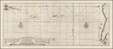
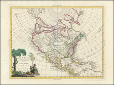
Rare Dutch edition of Gerhard Freidrich Muller's rare map of 1754, showing the Russian discoveries in the Northwest part of America, during the so called "Great Northern Expedition."
The Great Northern Expedition was one of the largest and best organized voyages of exploration, the results of which completely remapped most of the Arctic coast of Siberia and some parts of the Northwest coast of America, filling in vast amounts of previously unknown coastal details, which had been previously the subject matter of myth and speculation. Originally conceived by Russian Emperor Peter I the Great, the exploraton was undertaken under the auspices of Russian Empresses Anna and Elizabeth, under the direction of Vitus Bering. The expedition lasted roughly from 1733-1743. The goal was to find and map the eastern reaches of Siberia, and explore and map the Northwest Coast of America.
The important achievements of the expedition included the European discovery of Alaska, the Aleutian Islands, the Commander Islands, Bering Island, as well as a detailed mapping of the northern and north-eastern coast of Russia and the Kuril Islands. The expedition also ended the myth of a massive land mass in the North Pacific.
First published in 1754, Muller's map was the official Russian response to Joseph Nicolas Delisle's surreptious publication of his map of the same region. The Russians believed that Delisle had improperly used the information he had gathered while serving in St. Petersburg at the Royal Academy. Moreover, they were aware of his incorrect delineation of the Northwest Coast of America. Thus they encouraged Gerard Muller, a German cartographer working in St. Petersburg, to issue a map to correct Delisle's mistakes, as the official mapping from the Imperial Academy in St. Petersburg. Thomas Streeter notes that
This . . . map confirmed the existance of a body of water between Asia and America, the subject of much dispute during the previous two hundred years. It also showed the Kurile Islands correctly and suggested the outline of Alaska and the Aelutian chain. Though the Russian discoveries had been shown on the Delisle map. . . published in 1752 . . . his is the first map to give an approximate picture of what is now the Alaska peninsula . . . . The present map is copied from the 1758 issue, with the word Russes in the Title changed to Russiens, and the 1758 date given in the title cartouche; in the lower margins is the Amsterdam imprint and 1766 date and L. Schenck, Jansz: Sculpsit 1765.
Wagner notes that "the map seems to be the earliest to show the discoveries of Bering and Chirikof in 1741, with the tracks of the vessels in the north Pacific . . . ." Wagner 591.
The map appeared in the Dutch edition of Gerhard Friedrich Muller's Voyages et decouvertes par les Russes le long des cotes de la mer glaciale & sur l'ocean oriental . . . . and provides a fine rendition of the original 1754 map, which is now virtually unobtainable.
![[ Discovery of the Northwest Passage ] Chart Showing the Recent Search for a North-West Passage. Also the Coast Explored in Search of Sir John Franklin between the Years 1848 and 1854](https://storage.googleapis.com/raremaps/img/small/101874.jpg)
![[The United States in North America | Russian Empire in Europe] [Kita-Amerika-nai Gasshukoku | Yoroppa-nai teikoku Roshia]](https://storage.googleapis.com/raremaps/img/small/55548.jpg)