


|
||

|

|
|

|
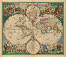
Old color example of Pierre Mortier's edition of De Wit's striking double hemisphere map of the World.
The map shows the Sanson model of California as an island and the Straits of Anian. New Geinea and the north parts of Australia are shown in this edition for the first ime
The brilliant scenes in the corners combine images of the four seasons, the elements and the signs of the zodiac in a well-balanced and natural way. According to Shirley, De Wit's map is one of the most attractive of its time.
De Wit (1629 ca.-1706) was a mapmaker and mapseller who was born in Gouda but who worked and died in Amsterdam. He moved to the city in 1648, where he opened a printing operation under the name of The Three Crabs; later, he changed the name of his shop to The White Chart. From the 1660s onward, he published atlases with a variety of maps; he is best known for these atlases and his Dutch town maps. After Frederik’s death in 1706, his wife Maria ran the shop for four years before selling it. Their son, Franciscus, was a stockfish merchant and had no interest in the map shop. At the auction to liquidate the de Wit stock, most of the plates went to Pieter Mortier, whose firm eventually became Covens & Mortier, one of the biggest cartography houses of the eighteenth century.
Pierre, or Pieter, Mortier (1661-1711) was a Dutch engraver, son of a French refugee. He was born in Leiden. In 1690 he was granted a privilege to publish French maps in Dutch lands. In 1693 he released the first and accompanying volume of the Neptune Francois. The third followed in 1700. His son, Cornelis (1699-1783), would partner with Johannes Covens I, creating one of the most important map publishing companies of the eighteenth century.
![(World - First State!) Benedict Arias Montanus Sacrae Geographiae Tabulam ex Antiquissimorum Cultor. [Pre-Dutch Discovery Depiction of Australia]](https://storage.googleapis.com/raremaps/img/small/93232.jpg)
![A General Atlas Containing Distinct Maps Of all the known Countries in the World. Constructed from the Latest Authority [Binder's title: Lucas's Cabinet Atlas]](https://storage.googleapis.com/raremaps/img/small/80266.jpg)
![(Second World War) Der Grossasiatisch-Amerikanische Raum [The Great Asiatic-American Space]](https://storage.googleapis.com/raremaps/img/small/88834.jpg)