|
||

|

|
|

|
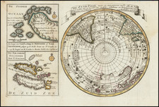
Rare Henri de Leth map of the Southern Hemisphere, published in Amsterdam.
The map shows many of the later cartographic myths and anomallies associated with the Southern Hemisphere.
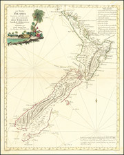
Excellent projections of Australia and New Zealand, along with a number of early routes of exploration from the 16th, 17th and 18th Centuries, including Tasman, Halley, Damiper, Magellan, Le Maire, Mendana and others.
Some of the more notable features are Edmund Halley's sighting of Antarctic ice; Bouvet's large Cap de la Circoncision; Carpentaria attached to New Guinea; Tasman's route, along with a depiction of Tasmania as per Tasman, distinctly separate from Australia.
On the edges of the map is an account of the 1738-9 expedition of Bouvet de Lozier, which mentions the discovery of icebergs between two and three hundred feet high and half a league to two or three leagues in circumference. Buache made Cap de la Circoncision at 54° south, below Africa, a northern promontory of the smaller of his two land masses, next to one of the openings of his polar sea, where Bouvet had recorded his many great icebergs.
There is a discusssion of Cap de la Circoncision, which would later become Bouvet Island. The island was discovered on January 1, 1739 by Jean-Baptiste Charles Bouvet de Lozier, commander of the French ships Aigle and Marie. This was the first time land had been spotted south of the 50th parallel south. Bouvet, who was searching for a presumed large southern continent, spotted the island through the fog and named the cape he saw Cap de la Circoncision. He was not able to land and did not circumnavigate his discovery, thus not clarifying if it was an island or part of a continent. but his plotting of its position was inaccurate forcing several expeditions to fail to find the island again.
The second state of the map includes the following additions and changes:
- Bouvet route, and marginal map and information
- The "port", allegedly discovered by Sir Francis Drake, otherwise known as Drake's Island, in 1577,which lies to the southwest of Cape Horn.
- The discoveries of Captain Davis and Captain Sharp to the west of the Straits of Magellan
- The annotations regarding Amerigo Vespucci's voyage to the Southern Hemisphere
- Different text in the lower corners and far fewer place names along the Chilean coast of South America
- Notes the islands discovered by Roggeveen in 1722.
- More detail in New Zealand.
The map is quite rare. We could not locate any examples at auction or in dealer catalogs in more than 30 years.