The item illustrated and described below is sold, but we
have another example in stock. To view the example which
is currently being offered for sale, click the
"View Details" button below.
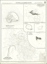
![[Hawaii] Carte Des Parties Des Iles Sandwich . . . 1786 By Jean Francois Galaup de La Perouse](https://storage.googleapis.com/raremaps/img/small/81545.jpg)
1797 Jean Francois Galaup de La Perouse
$ 750.00


|
||

|

|
|

|
Stock# 3454
Description
Two fascinating charts of the Hawaiian Islands, illustrating the charting of the islands before and after La Perouse's voyage. Despite the large scale of the map, La Perouse sailed though the islands within a matter of days, preventing a detailed charting of all coastlines. The islands are closer togher, owing to a differing interpretation of distances, as discussed in Fitzpatrick p.26. A fine example of one of the best 18th Century maps of Hawaii.
![[ Hawaii ] Free All Islands Map](https://storage.googleapis.com/raremaps/img/small/99157.jpg)