|
||

|

|
|

|
Rare Title Page / Map from the 1626 edition of John Smith's The Generall Historie of Virginia, New-England, and the Summer Isles, first published in London in 1624.
As noted by Burden:
The title page to this rare work included a map of the east coast of North America from Cape Fear to Penobscot Bay. The work brought together, amongst others, the relations of John Smth's experiences in Virginia and New England. Clearly the map was not intended to be accurate. The portraits of the two kings and Queen Elizabeth appeared within it. The latter is placed above Ould Virginia, reflecting her influence over Walter Raleigh's attempted colonization. James I is shown above the more successful Jamestown settlement, and Charles as prince is depicted over New England, an area for which he chose a number of the placenames. The area between Delaware Bay and Cape Cod is the poorest accuracy; however Hudson River is prominently displayed. The Atlantic Ocean is adorned with ships, including sunken ones off Cape Hatarask, sea monsters and a shoal of Cod.
Either side of the title itself are the arms of both the Virginia Company and the Council For New England . . .
This is the second state of the Title page, with Charles now shown as Charles Creux.
The complete book is an exception rarity. This is the first time we have seen a separate copy of the title page offered for sale.


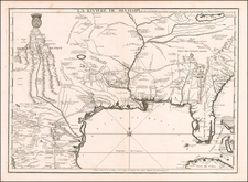
![[Rare First State] Novissima Tabula Regionis Ludovicianae Gallice dictae la Louisiane . . .](https://storage.googleapis.com/raremaps/img/small/72622.jpg)
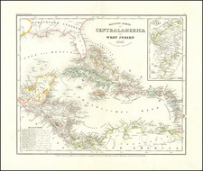
![[Rare Blaeu West Indische Pascaert Wall Map Section] Insulae Americanae in Oceano Septentrionali, cum terris adjacentibus](https://storage.googleapis.com/raremaps/img/small/75672.jpg)