|
||

|

|
|

|
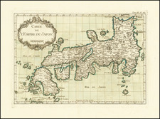
Finely engraved wide-margined example of Ferando Bertelli's rare map of China, the Philippines, Southeast Asia and Japan, one of the earliest printed maps to focus on the region one one of the earliest printed maps to name the Philippines (Filipina). The map is also sometimes attributed to Niccolo Nelli, the engraver.
Bertelli's map is based upon the first edition of Ramusio's map, which appeared in his Delle Navigation e Viaggi. The map draws heavily from the voyage of Magellan. It provides an update from Gastaldi's map of 1548, based upon new sources which became available during the intervening years. Bertelli's map was issued in the same year as the two extra sheets engraved by Paolo Forlani as extensions to Gastaldi's 2 sheet wall map of 1559, making this one of the two earliest Lafreri maps to extend south of the Equator in its treatment of Southeast Asia.
Tom Suarez notes that Ramusio's treatment of the region is a great advance from the 1548 map, relying upon Portugese charts and the works of Joao de Barros as principal sources for the updates. Suarez discusses this map, the 1548 Geographia map and a later Lafreri map of 1561 in Chapter 11 of his work on the Mapping of Southeast Asia. Among other important features of the map is that it is the first appearance of the name Philippines (Filipina) in any form on a European map. The map does not show Luzon, but applies the name Filipina to a narrow island to the east of Mindanao. The Spanish expedition leader Ruy Lopez de Villalobos bestowed the name Felipina on Leyte in honor of the young Crown Prince Philip (later Philip II) in 1543.
Ramusio's map first appeared in the second edition of Volume I of Giovanni Battista Ramusio's Delle Navigation e Viaggi. The 1554 Ramusio-Gastaldi map not only benefited from Antonio Pigafetta's account of Magellan's voyage for its mapping of the Philippines but also relied on newly published sources at the time. Among these sources is the account of the voyage from Mexico to the Philippines by Juan Gaytan and Villalobos.
A fire in the Ramusio print shop in November 1557 destroyed the woodblock that produced this map, shortly after Ramusio's death. As a result, few examples were printed before the destruction of the woodblock. In 1565, a copperplate edition of the map replaced the original woodblock. This map, issued in the same year as the second edition of Gastaldi's map, but is far rarer, with only a few examples located by bibliographers (not in Tooley) and even Suarez mis-dates the map as having been published in 1564.
We note two appearances of the map at auction in the past 30 years and no copies in dealer catalogs. The present example is especially fine, with untrimmed margins.
![[Cultural Revolution Maps - Map of France / A Sketch Map of Events of May 1968] [Fagu di tu - Faguo ren min ge ming dou zheng yi tu]](https://storage.googleapis.com/raremaps/img/small/88909.jpg)
![[ China Sea / Luzon / Hong Kong / Canton / Formosa ] Bogt Toncqin (VOC - Dutch East India Chart by Its Chief Map Maker in Batavia)](https://storage.googleapis.com/raremaps/img/small/64690.jpg)