|
||

|

|
|

|
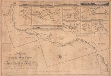
A Finely Executed Manuscript Map of Antonio de la Torre y Miranda's Expeditions to the Chocó region of Colombia, outlining his groundbreaking plan for an Interoceanic route from the Pacific to the Atlantic
The present work is an exquisitely drafted and highly detailed manuscript map of the Chocó region of northwestern Colombia, drafted by the Spanish military engineer Antonio de la Torre y Miranda, immediately following his six expeditions to the area, undertaken from 1774 to 1778. Importantly, the map depicts Torre's proposed grand project to discover the first navigable route connecting the Atlantic to the Pacific Oceans, across the American continental landmass. Such a design, if realized, would have dramatically transformed the economy of the Spanish Empire, bringing the vast riches of Peru to market in a far faster, safer and cost-effective manner. It would also open the Chocó region, long known to be rich in precious metals and timber to development.
The map represents the visual embodiment of Torre's remarkable 5-year enterprise and his remarkable vision for altering the routes of commerce in the northern part of the Spanish Empire in South America, a fascinating pre-cursor to ideas and explorations undertaken in the next century in aid of finding the most practicable route between the Pacific and the Atlantic.
Through virtuous flourishes of ink and wash, Torre captures the rugged topography and mighty fluvial systems of this wild and majestic corner of what was then the Captaincy General of Nueva Granada. Occupying a strategic triangle between the Caribbean Sea and the Pacific Ocean, the Chocó region is blessed by great rivers, most notably the Río Atrato and the Río Sinú. The river valleys are framed by dramatic ridges of the Andes, notably the Serranía de Baudo and the Cordillera Occidental, the slopes of which were covered by tropical rainforests, the source of valuable hardwood lumber. The rivers themselves yielded considerable amounts of placer gold and platinum. Importantly, it was thought that the fluvial corridors could provide a promising transpiration route from the Pacific to the Caribbean.The established route of taking goods by mule train across the Panamanian Isthmus was expensive, cumbersome and often dangerous. Opening up a navigable passage between the oceans could radically transform the flagging fortunes of the Spanish Empire that was then in steep economic decline. If realized, precious cargo, such as Peruvian silver and Ecuadorian cocoa, not to mention important official correspondence, could reach the Atlantic in mere days, and in so doing, could transform the Chocó from a backwater into a global nexus of trade.
In spite of all of this potential, the Chocó region remained one of the least developed areas of coastal Latin America. To begin with, the gateway to the region, the Gulf of Urabá, where the Río Atrato meets the Caribbean, lies at the juncture of the infamous 'Darien Gap'. There the great bulk of South America narrows to form the Panamanian Isthmus, and where malarial swamps and thick jungles had doomed previous attempts at colonization. The spectacular failure of the Scottish venture to develop the area three generations earlier was still very much in the mind's eye. If that was not sufficient to discourage Spanish adventurers, the Chocó's native peoples were fiercely independent and often violently resisted European encroachment. While permanent Spanish settlements, most notably, the town of Quibdó, located at he head of the navigation of the Atrato, had been in existence as early as the 1640s, they remained in fledgling states, as the lack of roads and other infrastructure hindered progress. While Jesuit missionaries had experienced some success in 'civilizing' the native peoples, since the society's suppression in the Spanish Empire in 1767, the semblance of order had broken down. The region was on its way to returning to a state of nature, at great opportunity cost to the Crown.
In 1772, Don Manuel de Guirior y Portal, the new arrived Viceroy of Nueva Granada, decided that bold action would be needed if the Chocó's promise were ever to be redeemed. Guiror was accompanied to the New World by Lieutenant Antonio de la Torre y Miranda (1734-1805), a highly enterprising military engineer. The Viceroy, who had known Torre since he was a young recruit in 1756, recognized that he was destined for greater things, and placed him in charge of the Chocó project. Torre's very ambitious mandate was to venture throughout the region, and by whatever means necessary, convince or compel the native peoples into settling into orderly towns and taking up agriculture in an effort to tame their independent sprint. Moreover, Torre was to gain a detailed appraisal of the region's true mineral wealth and its potential as an interoceanic transport corridor. Critically, in order to create a blueprint for these objectives, Torre was to conduct the first modern mapping of the region.
Torre, who was based in Cartagena, led a small band of soldiers on six separate expeditions into the region, from August 12, 1774 to May 3, 1778. Avoiding the rainy seasons as much as possible, they ascended both the Sinú and the Atrato rivers and their tributaries, seeking to find the most commodious passages thought the mountains, and then from the interior to the Pacific. Torre proved to be very intrepid and versatile, and with great diplomatic skill, he managed to convince many of the native communities to form fixed settlements and to try their hand at farming. In fact it was said that his efforts were responsible for the creation of the 43 villages throughout the region.
As depicted on the present map, Torre's reconnaissance of the Chocó was broad in its scope, yet highly meticulous. The intricate meanderings of the waterways are carefully detailed, with all of the swamplands clearly distinguished, and the innumerable tributaries named and labeled. While the Jesuits had made some effort the map the region, Torre's abilities were of a much higher caliber. Detailed by the legend, located to the lower center of the map, Torre identified a great diversity and quantity of sites important to the future development of the region. These include the locations of native towns, the best sites for new mines, as well as the location of a "newly discovered" native road, linking the Sinú with the Atrato rivers, whereupon he duly recommended locations for proposed outposts to guard this vital corridor.
Most importantly, Torre employed the present map to illustrate the potential interoceanic route that could represent a vast economic boon to Nueva Granada, if not the Spanish empire in general. As depicted on the map, Torre's route sees one ascending the Atrato, which is fully navigable for small vessels the 250 miles up to Quibdó, and then ascending the Río Quito up to one of it tributaries. At that point, Torre then proposed that a canal of a relatively short length be built (indicated by two parallel dotted lines), linking this tributary to the head of the Río San Juan, which flows directly into the Pacific. Presumably, if this canal could be built along with improvements made to the Río Quito, a fully navigable passage for small boats could be secured.
It was nothing short of a herculean achievement that Torre mounted six expeditions into what was considered to be one of the most difficult and dangerous regions in Latin America, all the while gathering first-class intelligence and subduing the natives. Torre was certainly a man of uncommon drive and vision. His story certainly deserves much greater recognition from historians.
In 1779, Torre drafted this manuscript which is the definitive graphic record of his mandate to subdue the restless native inhabitants and to reconnoiter the region in order to gain a full appraisal of its potential as a transportation corridor and the source of natural resources. He dedicated the map to Guirior's successor as viceroy, Don Manuel Antonio de Flores. It is nothing short of a masterpiece of Spanish colonial cartography, for it is not only the finest map of the Chocó produced during the eighteenth-century, but a superlative example of modern mapping done in the most challenging frontier conditions. It compares very favorably with the finest, and far better known, contemporary mapping endeavors in North America. It is also testament to the fact that even during the twilight of the Spanish Empire, there were still visionaries who proposed bold and credible designs that, if realized, could perhaps have revived imperial fortunes.
While Torre's vision was enticing, and the idea of an interoceanic passage through the Chocó captivated serious minds for decades to come, the plan was never brought to fruition. First, the Spanish policy of cartographic secrecy ensured that only a very limited number of high-level Spanish officials would have been privy to his map and his greater plans. Second, buffeted first by the American Revolution and then the Napoleonic Wars, Spain found itself entirely unable to invest in even the most promising colonial schemes. Indeed, it would not be long before she lost her American empire altogether. One is left to imagine what might have become of Torre's plan if it was not secreted away and barred from the support of worthy investors. The history of the region, and indeed of Latin America, may have taken a different course.
Nevertheless, in the nineteenth-century, the concept of an interoceanic canal through the Chocó returned to the fore. The legendary explorer and geographer Alexander von Humboldt commented favorably on the idea, noting that he had been informed that in 1788 a local priest had organized the natives to dig the so-called 'Raspadura Canal' at the very location between the Quito and San Juan headwaters Torre had highlighted (Humboldt, Political Essay of on the Kingdom of New Spain, vol. I, p.31). Torre, who subsequently explored the Orinoco, was certainly known to the German luminary by reputation, although we do not know if Humboldt was ever aware of the great Chocó map itself.
In any event, inspired by Humboldt's writings, the British Navy sponsored preliminary investigations of the route in 1824, 1827 and 1847. The fanfare generated so much enthusiasm that the Atrato and San Juan Canal & Transportation Company was organized in 1851. In 1852, John C. Trautwine, a surveyor working of the Panama Railroad Company, conducted a more detailed instrument survey of the region, and determined that the apocryphal 'Raspadura Canal' was just a 'canoe slide' built by the natives to get their vessels over the hills, and was never an actual waterway. It was determined that although it might be possible to create a route for small boats, by this age of steamships, the larger size and draw of vessels made the concept of transoceanic canal through the Chocó financially impracticable. Torre's great map and the plan it represents was nevertheless an example of bold and industrious thinking that was ahead of its time.
We are aware of only 1 variant example of this map in an institutional collection.
![[ Acapulco and Environs ] Disposition des Vaisseaux de l'Escadre commandee par Mr. Anson croisant, vis a vis d' Acapulco en 1742](https://storage.googleapis.com/raremaps/img/small/98783.jpg)