|
||

|

|
|

|
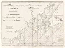
Rare 1865 British Admiralty sea chart of the Strait of Singapore.
The map covers from Singapore Island to Pulu Paril and from Great Carimon to Pulo Battam, focusing on the waters just south of Singapore, including extensive sounding details and sailing directions.
The basic survey work for this map was completed between 1846 and 1854 by John Turnbull Thomson (1821-1884). Thomson was born at Glorum, Northumberland, England, He was educated at Wooler and Duns Academy, later spending some time attached to Marischal College, Aberdeen, and Edinburgh University before studying engineering at Peter Nicholson's School of Engineering at Newcastle-on-Tyne.
Thomson arrived in the Malay Straits in 1838 and was employed by the East India Survey. In 1841 he was appointed Government Surveyor at Singapore and in 1844 became Superintendent of Roads and Public Works. He was responsible for the design and construction of a number of notable engineering works including bridges, roads, and hospitals. He conducted the allotment survey of Singapore, the topographical survey of the island of Singapore and its dependencies, and the marine survey of the Straits of Singapore and the east coasts of Johore and Penang. His outstanding achievement was the erection of the Horsburgh Lighthouse on Pedra Branca.
In 1853 his health failed and he returned to England where he studied modern engineering techniques, and travelled widely through Britain and the Continent inspecting engineering works. Early in 1856 he emigrated to New Zealand, where he worked as Chief Surveyor of the Otago Province until 1873. From 1876 until 1879 he was Surveyor-General of New Zealand.
From 1856 until 1858 Thomson surveyed and explored large sections of the interior of the South Island, covering most of the southern half of the island. Many names in the area bear witness to Thomson's Northumbrian background, though there is a widespread belief that the naming of many places was through a disagreement with the New Zealand surveying authorities. It has long been suggested that Thomson originally intended to give traditional Maori names to many places, but these names were refused. In response, Thomson gave prosaic Northumbrian names to many places, often simply in the form of a Northumbrian dialectic name for an animal. The Maniototo region around the town of Ranfurly, Central Otago is rife with such names as Kyeburn, Gimmerburn, Hoggetburn, and Wedderburn as a result, and the area is still occasionally referred to as "Thomson's Barnyard".
Thomson was a founder of the Otago and Southland Institutes of New Zealand, to which he contributed numerous papers on scientific subjects including ethnological studies. Through his knowledge of Hindustani and Malay, he became interested in comparative linguistics and developed a theory of racial diffusion based on philological evidence.
The British Admiralty has produced nautical charts since 1795 under the auspices of the United Kingdom Hydrographic Office (HO). Its main task was to provide the Royal Navy with navigational products and service, but since 1821 it has also sold charts to the public.
In 1795, King George III appointed Alexander Dalrymple, a pedantic geographer, to consolidate, catalogue, and improve the Royal Navy’s charts. He produced the first chart as the Hydrographer to the Admiralty in 1802. Dalrymple, known for his sticky personality, served until his death in 1808, when he was succeeded by Captain Thomas Hurd. The HO has been run by naval officers ever since.
Hurd professionalized the office and increased its efficiency. He was succeeded by the Arctic explorer Captain William Parry in 1823. By 1825, the HO was offering over seven hundred charts and views for sale. Under Parry, the HO also began to participate in exploratory expeditions. The first was a joint French-Spanish-British trip to the South Atlantic, a voyage organized in part by the Royal Society of London.
In 1829, Rear-Admiral Sir Francis Beaufort was appointed Hydrographer Royal. Under his management, the HO introduced the wind force scale named for him, as well as began issuing official tide tables (1833). It was under Beaufort that HMS Beagle completed several surveying missions, including its most famous voyage commanded by Captain FitzRoy with Charles Darwin onboard. When Beaufort retired in 1855, the HO had nearly two thousand charts in its catalog.
Later in the nineteenth century, the HO supported the Challenger expedition, which is credited with helping to found the discipline of oceanography. The HO participated in the International Meridian Conference which decided on the Greenwich Meridian as the Prime Meridian. Regulation and standardization of oceanic and navigational measures continued into the twentieth century, with the HO participating at the first International Hydrographic Organization meeting in 1921.
During World War II, the HO chart making facility moved to Taunton, the first purpose-built building it ever inhabited. In 1953, the first purpose-built survey ship went to sea, the HMS Vidal. Today, there is an entire class of survey vessels that make up the Royal Navy’s Hydrographic Squadron. The HO began to computerize their charts in the late 1960s and early 1970s. In 1968, the compilation staff also came to Taunton, and the HO continues to work from there today.


![[Signed Political Satire Artwork] Vietnam ... Vietnam ... Vietnam ...](https://storage.googleapis.com/raremaps/img/small/68726.jpg)