|
||

|

|
|

|
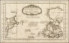
Rare sea chart covering the coastline of Alaska, British Columbia, Washington, Oregon and part of California, extending south to Mendocino, published by the United States Hydrographical Office in 1874.
The chart provides a finely detailed treatment of the Coastline, highlighting lighthouses in red and yellow and including soundings and significant coastal detail.
The section of the chart offered here includes most of the cartographic details on the complete chart, with most of the section not shown being blank areas of land to the east of the coastline and sea to the south. The missing section to the south is the coastline of California, extending south to Cabo San Lucas.
The chart is apparently very rare, as we have never seen a copy offered for sale on the market and the only 2 institutional examples illustrated on line are also badly damaged.
Link here for the University of Alaska copy: vilda.alaska.edu/cdm/singleitem/collection/cdmg11/id/15469/rec/11
Link here for the Huntington Library Copy: hdl.huntington.org/cdm/singleitem/collection/p15150coll4/id/2130/rec/9
This is the first Hydrographic Office map we have ever offered for sale.
![Charte von Nord-America Prag 1818 [Rare Alaska Inset Map]](https://storage.googleapis.com/raremaps/img/small/72184.jpg)