|
||

|

|
|

|
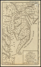
Fine example of the extremely rare French edition of Benjamin Eastburn's (but in fact Nicholas Scull's) map of Philadelphia.
Originally published in London by Andrew Dury in 1776, the so-called "Benjamin Eastburn map" is in actuality drawn from Nicholas Scull's map of the City, drawn in 1762, while Scull was surveying as Surveyor General of Pennsylvania. The Scull map is of the utmost importance, with Snyder referring to the map as "The first detailed map of the interior of the city ... completes his great contribution to Philadelphia iconography"
Apparently, Dury mistook Eastburn, who had been dead for 30 years and whose earlier map appeared as one of two insets on Scull's more modern map, as the true maker of the map, although omitting the insets from his edition of the map, which was in turn copied by Le Rouge, with the perpetuation of Dury's misattribution compounded by a mis-spelling of the name.
The map shows the layout of the city along the Delaware River with a western orientation. It extends as far inland as Eighth Street, indicating and naming each major building. Along the waterfront, several wharves are named.
The key at right identifies 23 locations.
George-Louis Le Rouge (1712-1790), though known for his work in Paris, was originally born Georg Ludwig of Hanover, Germany. He grew up and was educated in Hanover, after which he became a surveyor and military engineer. Around 1740, however, Le Rouge moved to Paris and set up shop as an engraver and publisher on the Rue des Grands Augustins. It was at this time that he changed his name, adopting a French pseudonym that would later become quite famous.
Le Rouge spent much of his forty-year career translating various works from English to French, and his cartographic influence often came from English maps. His experience as a surveyor and engineer in Germany made him a skilled and prolific cartographer, and he produced thousands of charts, maps, atlases, and plans. His work spans from garden views and small-town plans to huge, multiple-continent maps. Le Rouge eventually accepted the position of Geographical Engineer for Louid XV, the King of France.
Later in life, Le Rouge became well-known for publishing North American maps, such as in his Atlas ameriquain septentrional of 1778. One of Le Rouge’s other more famous works is the Franklin/Folger chart of the Gulf Stream, which he worked on with Benjamin Franklin. Franklin and Le Rouge corresponded around 1780 and collaborated to create this map, a French version of Franklin’s famous chart which was originally printed in 1769.