


|
||

|

|
|

|
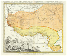
Scarce and highly decorative and detailed map of West Africa, published by the Heirs of Johann Baptiste Homann in Nuremberg.
The map extends from Cape Blanc and Senegal to Guinea Inferior and the Cacongo and Barbela Rivers. Also extends inland to including Ghana Lake on the Niger River.
This is without doubt one of the most detailed maps of the region during the mid 18th Century and is embellished with a stunning large vignette showing a native village scene, with a key at the bottom of the map identifying the various peoples and styles of habitats.
Homann Heirs was a German publishing firm that enjoyed a major place in the European map market throughout the eighteenth century. Founded in 1702 by Johann Baptist Homann, the business passed to his son, Christoph, upon Johann’s death in 1724. Christoph died in 1730, aged only 27, and the firm was inherited by subsequent Homann heirs. This altered the name of the company, which was known as Homann Erben, or Homann heirs. The firm continued in business until 1848.