


|
||

|

|
|

|
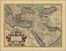
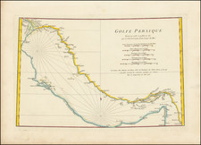
Striking original color example of the 1486 Ulm edition of Ptolemy's map of Iran and Iraq.
The present map is first printed map of the region printed north of the Alps and only the third printed maps of the region (pre-dated by the 1477 Bologna and 1478 Rome editions of Ptolemy's Geographia.
In 1482, Lienhart Holle published the first printed edition of Ptolemy's Geographia, published north of the Alps. The maps for the so-called "Ulm" edition were based upon manuscript maps drawn in the middle of the 15th Century by Donnus Nicolaus Germanus, a Benedictine cartographer and scholar who is credited with "modernizing" Ptolemy's Geographia by adding maps to the text and tables which had previously been handed down over the centuries, first in Greek and later Latin. He is also credited with creating terrestial and celestial globes in 1477, predating the globe of Martin Behaim.
The Ulm edition of Ptolmey was both the first atlas printed north of the Alps and the first with illustrated woodcut maps. The atlas also included five modern maps, which did not rely upon the traditional Ptolemaic model, Italy, Spain, France, Scandinavia, and the Holy Land.
While in modern times, the 1482 edition is greatly coveted among collectors for its beauty, the publication was not commercially successful for Holle, who was apparently bankrupted by the publication. His stock of unbound sheets, the woodblocks and movable type was transferred to Johann Reger in Ulm, who reissued the work in 1486. The 1482 edition is typically characterized by the blue color in the sea. The 1486 edition is generally includes a brown color in the sea.
The Ulm edition is also of note as the first time that maps were signed by the artisan who made the maps (Johannes of Armsheim), whose backwards N can be found in the woodcut text on each map. It is also the first appearance of hand coloring in a standardized style on a printed map and the first to include text on the verso of the map.
![Tabula IX Asiae [Pakistan & India] (Title on Verso)](https://storage.googleapis.com/raremaps/img/small/49098.jpg)