


|
||

|

|
|

|
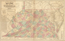
Fine example of the 1862 edition of JT Lloyd's large map of Virginia, the most widely distributed and influential map of Virginia duringthe Civil War period.
Lloyd's map of Virginia is often referred to as the reduced edition of Herman Boye's seminal map of Virginia, which Lloyd credits as the map's source. First issued in 1861, the map was perhaps the most successful of all of Lloyd's separately issued maps, which included maps of the US, Mississippi River, Georgia and Tennessee.
Lloyd's map is colored by county and includes marvelous detail throughout, including a number of interesting annotations. There were at least 4 other states of Lloyd map, including an 1872 edition by Wynkoop & Hallenbeck, with the Lynchburg overprinting.
The words: "Corrected and revised to 1862 by J. T. Lloyd from Surveys made by W. Angelo Powell, of the U.S. Topographical Engineers." are retained, as is Lloyd's name as the first word in the title. It appears that the only changes in the title area are the publication imprint and deleting reference to General McClellan.
![(Florida-Georgia) Wie der Franzosen Oberster eine Seul / daran das Wapen dess Königes auss Franckreich / aussrichten lassen. [How the French commander had a seal made, on which the coat of arms of the King of France is displayed.]](https://storage.googleapis.com/raremaps/img/small/95828.jpg)
![[ The Dying Bubble-Lord in the Lap of Madame Compagnie ] De stervende Bubbel-Heer in den schoot van Madame Compagne](https://storage.googleapis.com/raremaps/img/small/104094.jpg)

![[ First Map of Pennsylvania Province ] A Map of the Province of Pensilvania Drawn from the Best Authorities By T. Kitchin Gr.](https://storage.googleapis.com/raremaps/img/small/98226.jpg)