This item has been sold, but you can enter your email address to be notified if another example becomes available.


|
||

|

|
|

|
Stock# 33810
Description
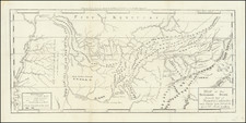
Scarce map showing the Seat of War in Virginia and Maryland, during the American Revolution.
The map extends west to the Alleghany Mountains and includes Delaware and the North part of North Carolina and Southern part of New Jersey and Philadelphia.
Includes good topographical details, counties, towns, rivers, mountains, lakes, etc.
Curiously, the map still shows the location near Fort Necessity where George Washington was captured by the British in 1754.
Condition Description
Minor expert repairs at fold intersection near the words "The Atlantic".

![(The First Letter From British Florida) [September 5, 1763, Autograph Letter, Signed, from Robert Campbell to John Campbell, 4th Earl of Loudoun, describing the British taking possession of Florida and the state of the settlement of Pensacola]](https://storage.googleapis.com/raremaps/img/small/86620.jpg)